You are here: Home > Network List > TA - USArray Transportable Network (new EarthScope stations) Stations List
> Station F23A Volborg, MT, USA > Earthquake Result Viewer
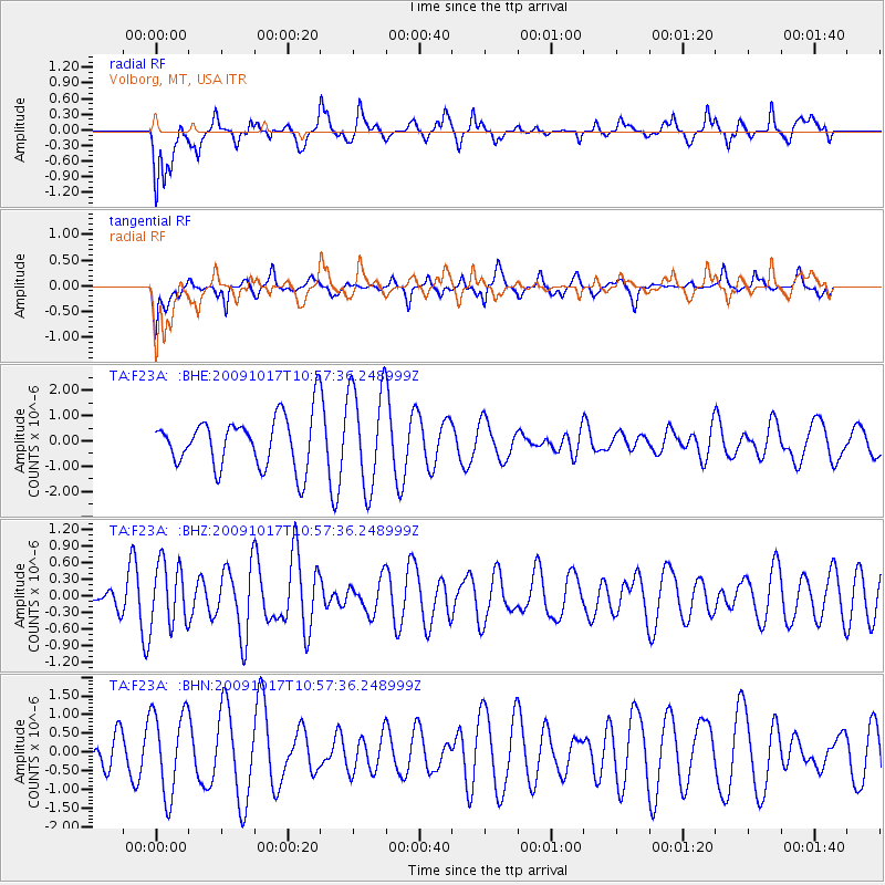
F23A Volborg, MT, USA - Earthquake Result Viewer
*The percent match for this event was below the threshold and hence no stack was calculated.
| Earthquake location: |
Samoa Islands Region |
| Earthquake latitude/longitude: |
-16.4/-172.0 |
| Earthquake time(UTC): |
2009/10/17 (290) 10:45:26 GMT |
| Earthquake Depth: |
10 km |
| Earthquake Magnitude: |
5.7 MB, 5.3 MS, 5.7 MW, 5.7 MW |
| Earthquake Catalog/Contributor: |
WHDF/NEIC |
|
| Network: |
TA USArray Transportable Network (new EarthScope stations) |
| Station: |
F23A Volborg, MT, USA |
| Lat/Lon: |
45.72 N/105.41 W |
| Elevation: |
953 m |
|
| Distance: |
86.1 deg |
| Az: |
40.114 deg |
| Baz: |
241.998 deg |
| Ray Param: |
$rayparam |
*The percent match for this event was below the threshold and hence was not used in the summary stack. |
|
| Radial Match: |
46.00869 % |
| Radial Bump: |
400 |
| Transverse Match: |
53.041412 % |
| Transverse Bump: |
400 |
| SOD ConfigId: |
2622 |
| Insert Time: |
2010-03-06 19:36:43.081 +0000 |
| GWidth: |
2.5 |
| Max Bumps: |
400 |
| Tol: |
0.001 |
|
Signal To Noise
| Channel | StoN | STA | LTA |
| TA:F23A: :BHZ:20091017T10:57:36.248999Z | 2.1722276 | 5.62578E-7 | 2.5898666E-7 |
| TA:F23A: :BHN:20091017T10:57:36.248999Z | 1.9170039 | 1.1247813E-6 | 5.867392E-7 |
| TA:F23A: :BHE:20091017T10:57:36.248999Z | 1.9932323 | 2.0062062E-6 | 1.0065089E-6 |
| Arrivals |
| Ps | |
| PpPs | |
| PsPs/PpSs | |


