You are here: Home > Network List > MM - Myanmar National Seismic Network Stations List
> Station TGI Taung Gyi, Myanmar > Earthquake Result Viewer
TGI Taung Gyi, Myanmar - Earthquake Result Viewer
| Earthquake location: |
Prince Edward Islands Region |
| Earthquake latitude/longitude: |
-43.1/42.3 |
| Earthquake time(UTC): |
2019/01/22 (022) 19:01:43 GMT |
| Earthquake Depth: |
13 km |
| Earthquake Magnitude: |
6.7 Mww |
| Earthquake Catalog/Contributor: |
NEIC PDE/us |
|
| Network: |
MM Myanmar National Seismic Network |
| Station: |
TGI Taung Gyi, Myanmar |
| Lat/Lon: |
20.77 N/97.03 E |
| Elevation: |
1458 m |
|
| Distance: |
81.0 deg |
| Az: |
50.65 deg |
| Baz: |
217.236 deg |
| Ray Param: |
0.04786383 |
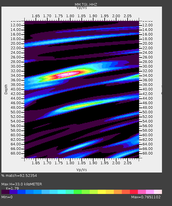
| Estimated Moho Depth: |
33.0 km |
| Estimated Crust Vp/Vs: |
1.79 |
| Assumed Crust Vp: |
6.316 km/s |
| Estimated Crust Vs: |
3.528 km/s |
| Estimated Crust Poisson's Ratio: |
0.27 |
|
| Radial Match: |
92.52354 % |
| Radial Bump: |
347 |
| Transverse Match: |
81.852844 % |
| Transverse Bump: |
400 |
| SOD ConfigId: |
13570011 |
| Insert Time: |
2019-05-02 09:01:28.856 +0000 |
| GWidth: |
2.5 |
| Max Bumps: |
400 |
| Tol: |
0.001 |
|

Signal To Noise
| Channel | StoN | STA | LTA |
| MM:TGI: :HHZ:20190122T19:13:26.55998Z | 43.724407 | 3.4235056E-6 | 7.829736E-8 |
| MM:TGI: :HHN:20190122T19:13:26.55998Z | 16.82254 | 1.0181659E-6 | 6.052391E-8 |
| MM:TGI: :HHE:20190122T19:13:26.55998Z | 11.020096 | 7.6438636E-7 | 6.936295E-8 |
| Arrivals |
| Ps | 4.2 SECOND |
| PpPs | 14 SECOND |
| PsPs/PpSs | 18 SECOND |


