You are here: Home > Network List > US - United States National Seismic Network Stations List
> Station LKWY Lake (Yellowstone--Lake), Wyoming, USA > Earthquake Result Viewer
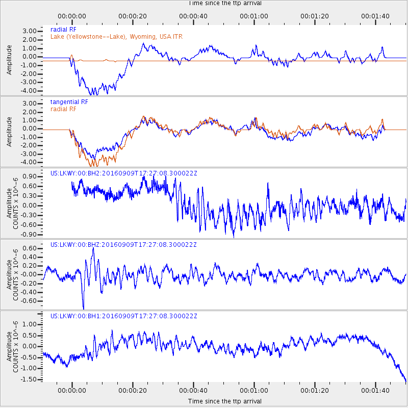
LKWY Lake (Yellowstone--Lake), Wyoming, USA - Earthquake Result Viewer
*The percent match for this event was below the threshold and hence no stack was calculated.
| Earthquake location: |
Northern Mid-Atlantic Ridge |
| Earthquake latitude/longitude: |
22.1/-45.9 |
| Earthquake time(UTC): |
2016/09/09 (253) 17:17:54 GMT |
| Earthquake Depth: |
10 km |
| Earthquake Magnitude: |
5.5 MB |
| Earthquake Catalog/Contributor: |
NEIC PDE/NEIC COMCAT |
|
| Network: |
US United States National Seismic Network |
| Station: |
LKWY Lake (Yellowstone--Lake), Wyoming, USA |
| Lat/Lon: |
44.57 N/110.40 W |
| Elevation: |
2424 m |
|
| Distance: |
56.9 deg |
| Az: |
309.579 deg |
| Baz: |
90.77 deg |
| Ray Param: |
$rayparam |
*The percent match for this event was below the threshold and hence was not used in the summary stack. |
|
| Radial Match: |
26.184996 % |
| Radial Bump: |
400 |
| Transverse Match: |
21.553268 % |
| Transverse Bump: |
400 |
| SOD ConfigId: |
1634031 |
| Insert Time: |
2016-09-23 17:24:26.880 +0000 |
| GWidth: |
2.5 |
| Max Bumps: |
400 |
| Tol: |
0.001 |
|
Signal To Noise
| Channel | StoN | STA | LTA |
| US:LKWY:00:BHZ:20160909T17:27:08.300022Z | 2.4521005 | 2.5029902E-7 | 1.0207535E-7 |
| US:LKWY:00:BH1:20160909T17:27:08.300022Z | 0.37641585 | 3.4018015E-7 | 9.0373493E-7 |
| US:LKWY:00:BH2:20160909T17:27:08.300022Z | 1.5772023 | 2.5128486E-7 | 1.5932315E-7 |
| Arrivals |
| Ps | |
| PpPs | |
| PsPs/PpSs | |


