You are here: Home > Network List > CB - China National Seismic Network Stations List
> Station GZH Guangzhou,Guangdong Province > Earthquake Result Viewer
GZH Guangzhou,Guangdong Province - Earthquake Result Viewer
| Earthquake location: |
South Of Sumbawa, Indonesia |
| Earthquake latitude/longitude: |
-10.3/118.9 |
| Earthquake time(UTC): |
2019/01/23 (023) 11:39:01 GMT |
| Earthquake Depth: |
15 km |
| Earthquake Magnitude: |
5.5 Mww |
| Earthquake Catalog/Contributor: |
NEIC PDE/us |
|
| Network: |
CB China National Seismic Network |
| Station: |
GZH Guangzhou,Guangdong Province |
| Lat/Lon: |
23.65 N/113.65 E |
| Elevation: |
65 m |
|
| Distance: |
34.1 deg |
| Az: |
351.359 deg |
| Baz: |
170.721 deg |
| Ray Param: |
0.077872075 |
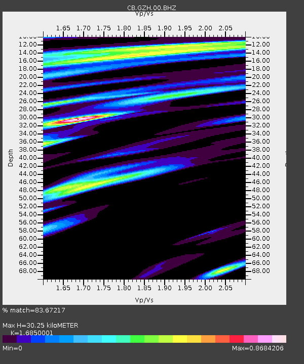
| Estimated Moho Depth: |
30.25 km |
| Estimated Crust Vp/Vs: |
1.69 |
| Assumed Crust Vp: |
6.276 km/s |
| Estimated Crust Vs: |
3.725 km/s |
| Estimated Crust Poisson's Ratio: |
0.23 |
|
| Radial Match: |
83.67217 % |
| Radial Bump: |
314 |
| Transverse Match: |
59.456066 % |
| Transverse Bump: |
400 |
| SOD ConfigId: |
13570011 |
| Insert Time: |
2019-05-02 09:03:33.893 +0000 |
| GWidth: |
2.5 |
| Max Bumps: |
400 |
| Tol: |
0.001 |
|

Signal To Noise
| Channel | StoN | STA | LTA |
| CB:GZH:00:BHZ:20190123T11:45:14.81999Z | 4.989769 | 1.6821803E-6 | 3.371259E-7 |
| CB:GZH:00:BHN:20190123T11:45:14.81999Z | 4.762819 | 9.275124E-7 | 1.9474022E-7 |
| CB:GZH:00:BHE:20190123T11:45:14.81999Z | 0.87613773 | 2.3299846E-7 | 2.6593816E-7 |
| Arrivals |
| Ps | 3.6 SECOND |
| PpPs | 12 SECOND |
| PsPs/PpSs | 16 SECOND |


