You are here: Home > Network List > US - United States National Seismic Network Stations List
> Station MNTX Cornudas Mountains, Texas, USA > Earthquake Result Viewer
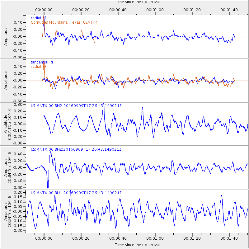
MNTX Cornudas Mountains, Texas, USA - Earthquake Result Viewer
*The percent match for this event was below the threshold and hence no stack was calculated.
| Earthquake location: |
Northern Mid-Atlantic Ridge |
| Earthquake latitude/longitude: |
22.1/-45.9 |
| Earthquake time(UTC): |
2016/09/09 (253) 17:17:54 GMT |
| Earthquake Depth: |
10 km |
| Earthquake Magnitude: |
5.5 MB |
| Earthquake Catalog/Contributor: |
NEIC PDE/NEIC COMCAT |
|
| Network: |
US United States National Seismic Network |
| Station: |
MNTX Cornudas Mountains, Texas, USA |
| Lat/Lon: |
31.70 N/105.38 W |
| Elevation: |
404 m |
|
| Distance: |
53.4 deg |
| Az: |
293.742 deg |
| Baz: |
84.776 deg |
| Ray Param: |
$rayparam |
*The percent match for this event was below the threshold and hence was not used in the summary stack. |
|
| Radial Match: |
63.81296 % |
| Radial Bump: |
400 |
| Transverse Match: |
50.49999 % |
| Transverse Bump: |
400 |
| SOD ConfigId: |
1634031 |
| Insert Time: |
2016-09-23 17:24:33.918 +0000 |
| GWidth: |
2.5 |
| Max Bumps: |
400 |
| Tol: |
0.001 |
|
Signal To Noise
| Channel | StoN | STA | LTA |
| US:MNTX:00:BHZ:20160909T17:26:43.149021Z | 3.2643776 | 2.9495436E-7 | 9.035547E-8 |
| US:MNTX:00:BH1:20160909T17:26:43.149021Z | 0.7670413 | 5.5709936E-8 | 7.2629646E-8 |
| US:MNTX:00:BH2:20160909T17:26:43.149021Z | 1.6192034 | 1.4027513E-7 | 8.6632184E-8 |
| Arrivals |
| Ps | |
| PpPs | |
| PsPs/PpSs | |


