You are here: Home > Network List > TJ - Tajikistan National Seismic Network Stations List
> Station GARM Garm, Tajikistan > Earthquake Result Viewer
GARM Garm, Tajikistan - Earthquake Result Viewer
| Earthquake location: |
South Of Sumbawa, Indonesia |
| Earthquake latitude/longitude: |
-10.3/118.9 |
| Earthquake time(UTC): |
2019/01/23 (023) 11:39:01 GMT |
| Earthquake Depth: |
15 km |
| Earthquake Magnitude: |
5.5 Mww |
| Earthquake Catalog/Contributor: |
NEIC PDE/us |
|
| Network: |
TJ Tajikistan National Seismic Network |
| Station: |
GARM Garm, Tajikistan |
| Lat/Lon: |
39.00 N/70.32 E |
| Elevation: |
1305 m |
|
| Distance: |
66.7 deg |
| Az: |
320.467 deg |
| Baz: |
126.498 deg |
| Ray Param: |
0.057431743 |
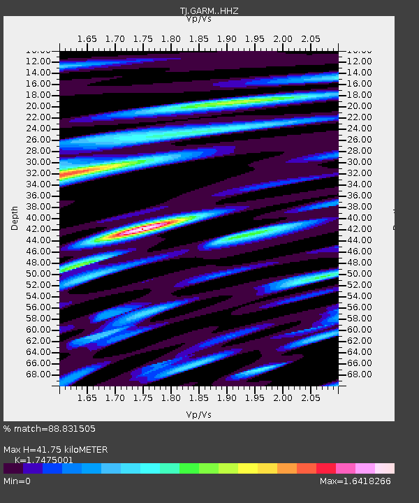
| Estimated Moho Depth: |
41.75 km |
| Estimated Crust Vp/Vs: |
1.75 |
| Assumed Crust Vp: |
6.306 km/s |
| Estimated Crust Vs: |
3.609 km/s |
| Estimated Crust Poisson's Ratio: |
0.26 |
|
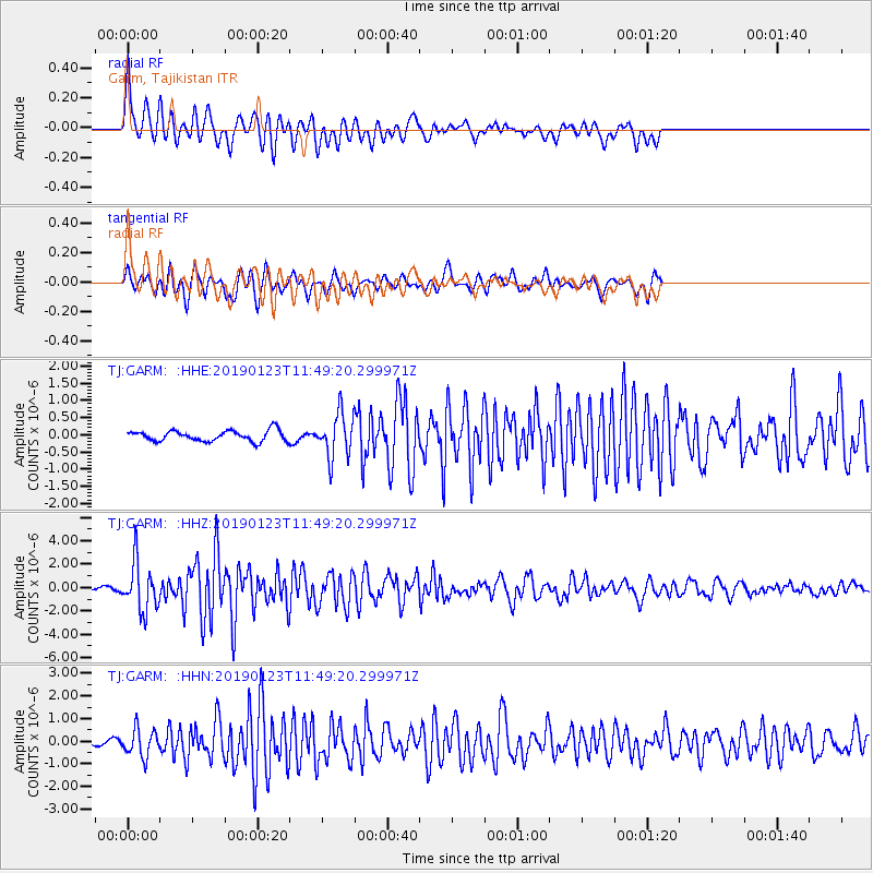
| Radial Match: |
88.831505 % |
| Radial Bump: |
399 |
| Transverse Match: |
80.60585 % |
| Transverse Bump: |
400 |
| SOD ConfigId: |
13570011 |
| Insert Time: |
2019-05-02 09:05:46.920 +0000 |
| GWidth: |
2.5 |
| Max Bumps: |
400 |
| Tol: |
0.001 |
|
Signal To Noise
| Channel | StoN | STA | LTA |
| TJ:GARM: :HHZ:20190123T11:49:20.299971Z | 16.94428 | 2.0768696E-6 | 1.2257053E-7 |
| TJ:GARM: :HHN:20190123T11:49:20.299971Z | 4.946652 | 5.988221E-7 | 1.2105605E-7 |
| TJ:GARM: :HHE:20190123T11:49:20.299971Z | 4.1907897 | 6.399752E-7 | 1.5270992E-7 |
| Arrivals |
| Ps | 5.1 SECOND |
| PpPs | 17 SECOND |
| PsPs/PpSs | 23 SECOND |


