You are here: Home > Network List > CN - Canadian National Seismograph Network Stations List
> Station INK INUVIK, NT > Earthquake Result Viewer
INK INUVIK, NT - Earthquake Result Viewer
*The percent match for this event was below the threshold and hence no stack was calculated.
| Earthquake location: |
Philippine Islands Region |
| Earthquake latitude/longitude: |
19.2/121.1 |
| Earthquake time(UTC): |
2019/01/24 (024) 08:34:53 GMT |
| Earthquake Depth: |
23 km |
| Earthquake Magnitude: |
5.5 Mww |
| Earthquake Catalog/Contributor: |
NEIC PDE/us |
|
| Network: |
CN Canadian National Seismograph Network |
| Station: |
INK INUVIK, NT |
| Lat/Lon: |
68.31 N/133.53 W |
| Elevation: |
44 m |
|
| Distance: |
77.8 deg |
| Az: |
21.522 deg |
| Baz: |
291.21 deg |
| Ray Param: |
$rayparam |
*The percent match for this event was below the threshold and hence was not used in the summary stack. |
|
| Radial Match: |
40.572094 % |
| Radial Bump: |
400 |
| Transverse Match: |
59.590694 % |
| Transverse Bump: |
400 |
| SOD ConfigId: |
13570011 |
| Insert Time: |
2019-05-02 09:07:46.293 +0000 |
| GWidth: |
2.5 |
| Max Bumps: |
400 |
| Tol: |
0.001 |
|
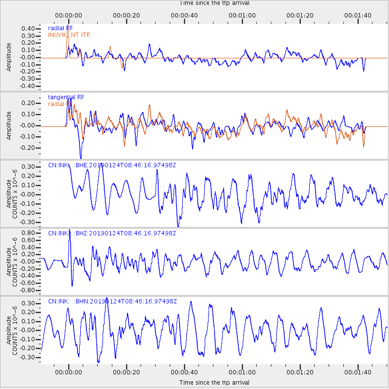
Signal To Noise
| Channel | StoN | STA | LTA |
| CN:INK: :BHZ:20190124T08:46:16.97498Z | 2.660276 | 3.3155587E-7 | 1.2463214E-7 |
| CN:INK: :BHN:20190124T08:46:16.97498Z | 1.0571747 | 1.6561553E-7 | 1.5665861E-7 |
| CN:INK: :BHE:20190124T08:46:16.97498Z | 0.94508445 | 1.2953629E-7 | 1.370632E-7 |
| Arrivals |
| Ps | |
| PpPs | |
| PsPs/PpSs | |


