You are here: Home > Network List > US - United States National Seismic Network Stations List
> Station WMOK Wichita Mountains, Oklahoma, USA > Earthquake Result Viewer
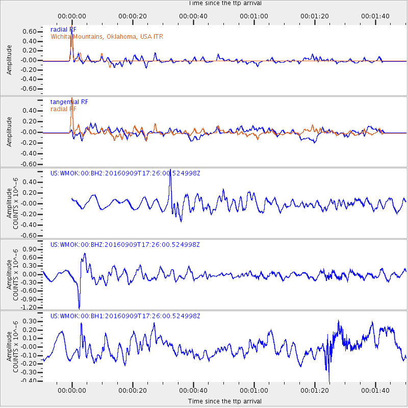
WMOK Wichita Mountains, Oklahoma, USA - Earthquake Result Viewer
*The percent match for this event was below the threshold and hence no stack was calculated.
| Earthquake location: |
Northern Mid-Atlantic Ridge |
| Earthquake latitude/longitude: |
22.1/-45.9 |
| Earthquake time(UTC): |
2016/09/09 (253) 17:17:54 GMT |
| Earthquake Depth: |
10 km |
| Earthquake Magnitude: |
5.5 MB |
| Earthquake Catalog/Contributor: |
NEIC PDE/NEIC COMCAT |
|
| Network: |
US United States National Seismic Network |
| Station: |
WMOK Wichita Mountains, Oklahoma, USA |
| Lat/Lon: |
34.74 N/98.78 W |
| Elevation: |
486 m |
|
| Distance: |
47.7 deg |
| Az: |
297.375 deg |
| Baz: |
90.691 deg |
| Ray Param: |
$rayparam |
*The percent match for this event was below the threshold and hence was not used in the summary stack. |
|
| Radial Match: |
73.45846 % |
| Radial Bump: |
400 |
| Transverse Match: |
32.014847 % |
| Transverse Bump: |
400 |
| SOD ConfigId: |
1634031 |
| Insert Time: |
2016-09-23 17:24:53.844 +0000 |
| GWidth: |
2.5 |
| Max Bumps: |
400 |
| Tol: |
0.001 |
|
Signal To Noise
| Channel | StoN | STA | LTA |
| US:WMOK:00:BHZ:20160909T17:26:00.524998Z | 4.195345 | 5.094992E-7 | 1.2144395E-7 |
| US:WMOK:00:BH1:20160909T17:26:00.524998Z | 1.2837821 | 1.4295225E-7 | 1.1135241E-7 |
| US:WMOK:00:BH2:20160909T17:26:00.524998Z | 2.7757647 | 2.1020297E-7 | 7.5727954E-8 |
| Arrivals |
| Ps | |
| PpPs | |
| PsPs/PpSs | |


