You are here: Home > Network List > TA - USArray Transportable Network (new EarthScope stations) Stations List
> Station E20K Nigu River, AK, USA > Earthquake Result Viewer
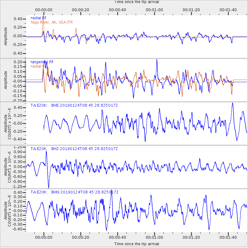
E20K Nigu River, AK, USA - Earthquake Result Viewer
*The percent match for this event was below the threshold and hence no stack was calculated.
| Earthquake location: |
Philippine Islands Region |
| Earthquake latitude/longitude: |
19.2/121.1 |
| Earthquake time(UTC): |
2019/01/24 (024) 08:34:53 GMT |
| Earthquake Depth: |
23 km |
| Earthquake Magnitude: |
5.5 Mww |
| Earthquake Catalog/Contributor: |
NEIC PDE/us |
|
| Network: |
TA USArray Transportable Network (new EarthScope stations) |
| Station: |
E20K Nigu River, AK, USA |
| Lat/Lon: |
68.26 N/156.19 W |
| Elevation: |
866 m |
|
| Distance: |
69.6 deg |
| Az: |
23.224 deg |
| Baz: |
270.617 deg |
| Ray Param: |
$rayparam |
*The percent match for this event was below the threshold and hence was not used in the summary stack. |
|
| Radial Match: |
47.50821 % |
| Radial Bump: |
369 |
| Transverse Match: |
62.524696 % |
| Transverse Bump: |
384 |
| SOD ConfigId: |
13570011 |
| Insert Time: |
2019-05-02 09:10:13.076 +0000 |
| GWidth: |
2.5 |
| Max Bumps: |
400 |
| Tol: |
0.001 |
|
Signal To Noise
| Channel | StoN | STA | LTA |
| TA:E20K: :BHZ:20190124T08:45:28.825017Z | 2.6656983 | 5.1410495E-7 | 1.9285939E-7 |
| TA:E20K: :BHN:20190124T08:45:28.825017Z | 1.4353043 | 1.6683346E-7 | 1.16235604E-7 |
| TA:E20K: :BHE:20190124T08:45:28.825017Z | 1.2848506 | 1.5215333E-7 | 1.18421035E-7 |
| Arrivals |
| Ps | |
| PpPs | |
| PsPs/PpSs | |


