You are here: Home > Network List > TA - USArray Transportable Network (new EarthScope stations) Stations List
> Station F26K Sheenjek River, AK, USA > Earthquake Result Viewer
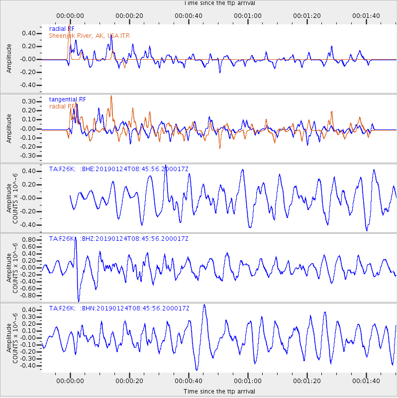
F26K Sheenjek River, AK, USA - Earthquake Result Viewer
*The percent match for this event was below the threshold and hence no stack was calculated.
| Earthquake location: |
Philippine Islands Region |
| Earthquake latitude/longitude: |
19.2/121.1 |
| Earthquake time(UTC): |
2019/01/24 (024) 08:34:53 GMT |
| Earthquake Depth: |
23 km |
| Earthquake Magnitude: |
5.5 Mww |
| Earthquake Catalog/Contributor: |
NEIC PDE/us |
|
| Network: |
TA USArray Transportable Network (new EarthScope stations) |
| Station: |
F26K Sheenjek River, AK, USA |
| Lat/Lon: |
67.69 N/144.15 W |
| Elevation: |
683 m |
|
| Distance: |
74.1 deg |
| Az: |
23.297 deg |
| Baz: |
281.799 deg |
| Ray Param: |
$rayparam |
*The percent match for this event was below the threshold and hence was not used in the summary stack. |
|
| Radial Match: |
66.1801 % |
| Radial Bump: |
400 |
| Transverse Match: |
58.878887 % |
| Transverse Bump: |
389 |
| SOD ConfigId: |
13570011 |
| Insert Time: |
2019-05-02 09:10:22.908 +0000 |
| GWidth: |
2.5 |
| Max Bumps: |
400 |
| Tol: |
0.001 |
|
Signal To Noise
| Channel | StoN | STA | LTA |
| TA:F26K: :BHZ:20190124T08:45:56.200017Z | 2.802244 | 4.6162242E-7 | 1.6473314E-7 |
| TA:F26K: :BHN:20190124T08:45:56.200017Z | 0.8616025 | 1.06713884E-7 | 1.2385513E-7 |
| TA:F26K: :BHE:20190124T08:45:56.200017Z | 1.627005 | 2.2187281E-7 | 1.3636885E-7 |
| Arrivals |
| Ps | |
| PpPs | |
| PsPs/PpSs | |


