You are here: Home > Network List > TA - USArray Transportable Network (new EarthScope stations) Stations List
> Station G22A Birney, MT, USA > Earthquake Result Viewer
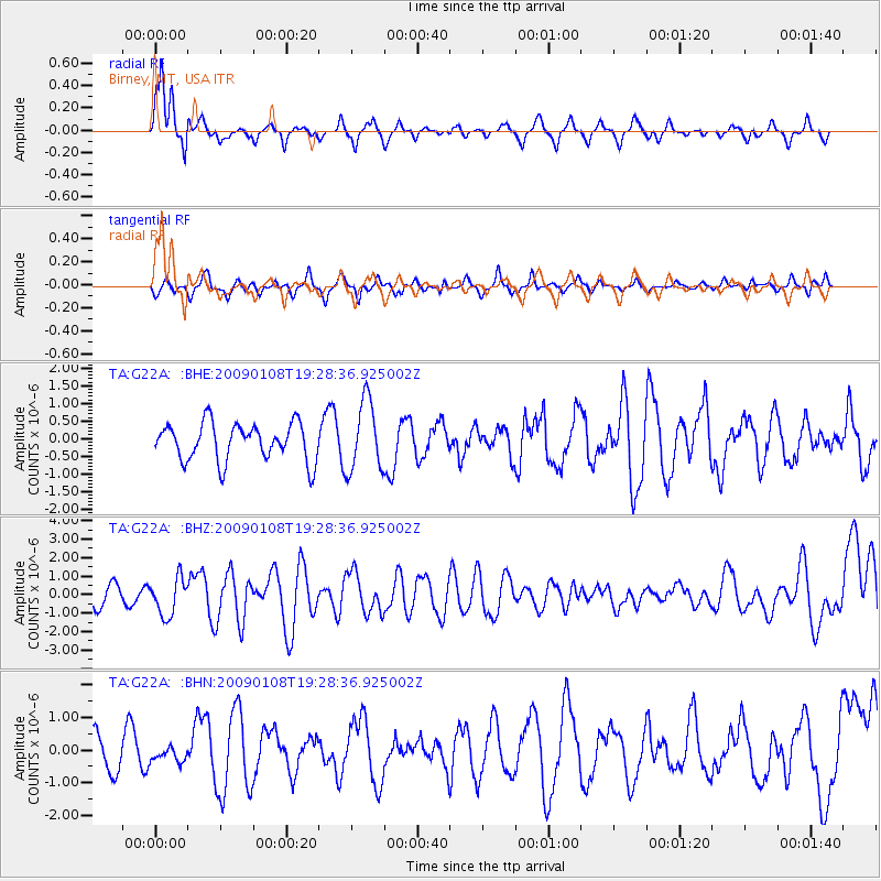
G22A Birney, MT, USA - Earthquake Result Viewer

| Earthquake location: |
Costa Rica |
| Earthquake latitude/longitude: |
10.2/-84.2 |
| Earthquake time(UTC): |
2009/01/08 (008) 19:21:35 GMT |
| Earthquake Depth: |
14 km |
| Earthquake Magnitude: |
5.7 MB, 6.0 MS, 6.1 MW, 6.1 MW |
| Earthquake Catalog/Contributor: |
WHDF/NEIC |
|
| Network: |
TA USArray Transportable Network (new EarthScope stations) |
| Station: |
G22A Birney, MT, USA |
| Lat/Lon: |
45.22 N/106.29 W |
| Elevation: |
1203 m |
|
| Distance: |
39.8 deg |
| Az: |
335.436 deg |
| Baz: |
144.616 deg |
| Ray Param: |
0.07478917 |
| Estimated Moho Depth: |
16.5 km |
| Estimated Crust Vp/Vs: |
1.92 |
| Assumed Crust Vp: |
6.178 km/s |
| Estimated Crust Vs: |
3.218 km/s |
| Estimated Crust Poisson's Ratio: |
0.31 |
|
| Radial Match: |
81.827805 % |
| Radial Bump: |
305 |
| Transverse Match: |
52.885265 % |
| Transverse Bump: |
343 |
| SOD ConfigId: |
2834 |
| Insert Time: |
2010-03-06 19:37:38.385 +0000 |
| GWidth: |
2.5 |
| Max Bumps: |
400 |
| Tol: |
0.001 |
|
Signal To Noise
| Channel | StoN | STA | LTA |
| TA:G22A: :BHZ:20090108T19:28:36.925002Z | 2.0218406 | 1.0108256E-6 | 4.9995316E-7 |
| TA:G22A: :BHN:20090108T19:28:36.925002Z | 0.47964337 | 2.2113711E-7 | 4.6104486E-7 |
| TA:G22A: :BHE:20090108T19:28:36.925002Z | 1.8787327 | 9.961799E-7 | 5.3024036E-7 |
| Arrivals |
| Ps | 2.6 SECOND |
| PpPs | 7.3 SECOND |
| PsPs/PpSs | 10.0 SECOND |


