You are here: Home > Network List > TA - USArray Transportable Network (new EarthScope stations) Stations List
> Station G22A Birney, MT, USA > Earthquake Result Viewer
G22A Birney, MT, USA - Earthquake Result Viewer
| Earthquake location: |
Kuril Islands |
| Earthquake latitude/longitude: |
48.3/154.2 |
| Earthquake time(UTC): |
2009/09/10 (253) 02:46:50 GMT |
| Earthquake Depth: |
36 km |
| Earthquake Magnitude: |
6.0 MB, 5.5 MS, 6.0 MW, 5.8 MW |
| Earthquake Catalog/Contributor: |
WHDF/NEIC |
|
| Network: |
TA USArray Transportable Network (new EarthScope stations) |
| Station: |
G22A Birney, MT, USA |
| Lat/Lon: |
45.22 N/106.29 W |
| Elevation: |
1203 m |
|
| Distance: |
63.3 deg |
| Az: |
51.262 deg |
| Baz: |
312.552 deg |
| Ray Param: |
0.059581824 |
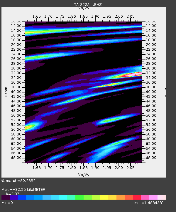
| Estimated Moho Depth: |
32.25 km |
| Estimated Crust Vp/Vs: |
2.07 |
| Assumed Crust Vp: |
6.178 km/s |
| Estimated Crust Vs: |
2.985 km/s |
| Estimated Crust Poisson's Ratio: |
0.35 |
|
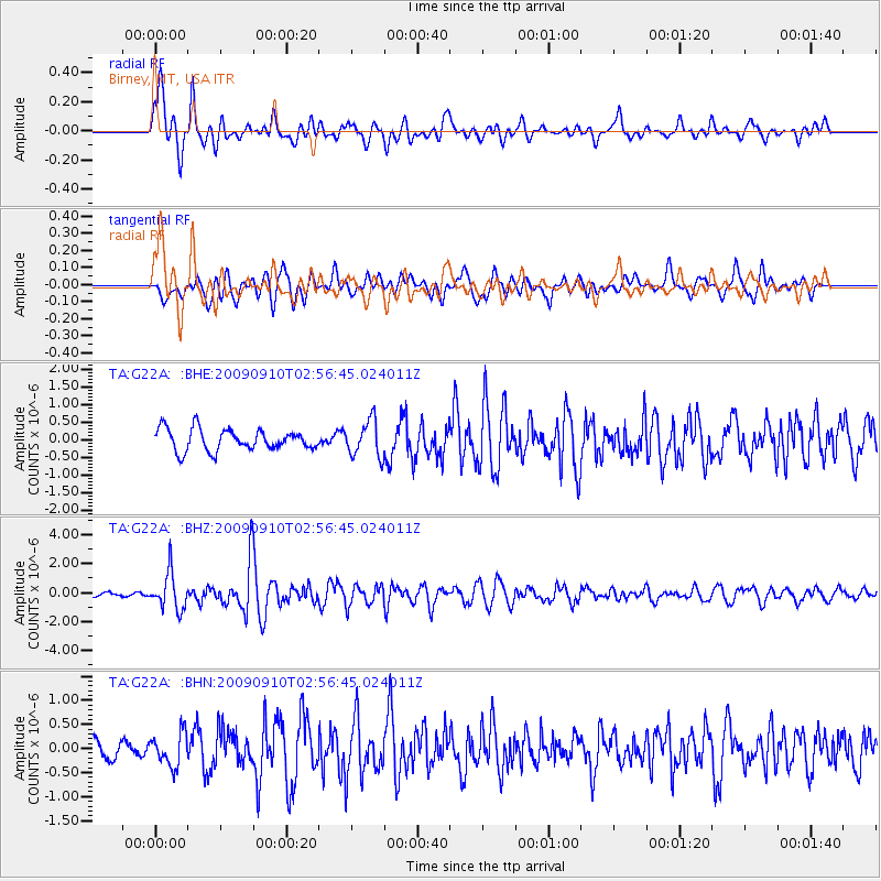
| Radial Match: |
80.2882 % |
| Radial Bump: |
400 |
| Transverse Match: |
72.2425 % |
| Transverse Bump: |
400 |
| SOD ConfigId: |
2622 |
| Insert Time: |
2010-03-06 19:37:46.217 +0000 |
| GWidth: |
2.5 |
| Max Bumps: |
400 |
| Tol: |
0.001 |
|
Signal To Noise
| Channel | StoN | STA | LTA |
| TA:G22A: :BHZ:20090910T02:56:45.024011Z | 9.388496 | 1.2662512E-6 | 1.3487262E-7 |
| TA:G22A: :BHN:20090910T02:56:45.024011Z | 1.6803067 | 3.41905E-7 | 2.0347774E-7 |
| TA:G22A: :BHE:20090910T02:56:45.024011Z | 1.7049887 | 5.157219E-7 | 3.024782E-7 |
| Arrivals |
| Ps | 5.8 SECOND |
| PpPs | 15 SECOND |
| PsPs/PpSs | 21 SECOND |


