You are here: Home > Network List > TA - USArray Transportable Network (new EarthScope stations) Stations List
> Station G22A Birney, MT, USA > Earthquake Result Viewer
G22A Birney, MT, USA - Earthquake Result Viewer
| Earthquake location: |
Panama |
| Earthquake latitude/longitude: |
9.6/-79.0 |
| Earthquake time(UTC): |
2009/07/04 (185) 06:49:35 GMT |
| Earthquake Depth: |
38 km |
| Earthquake Magnitude: |
6.0 MB, 5.5 MS, 6.0 MW, 6.0 MW |
| Earthquake Catalog/Contributor: |
WHDF/NEIC |
|
| Network: |
TA USArray Transportable Network (new EarthScope stations) |
| Station: |
G22A Birney, MT, USA |
| Lat/Lon: |
45.22 N/106.29 W |
| Elevation: |
1203 m |
|
| Distance: |
42.6 deg |
| Az: |
331.346 deg |
| Baz: |
138.002 deg |
| Ray Param: |
0.07301078 |
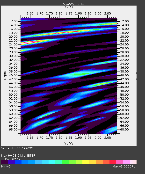
| Estimated Moho Depth: |
23.0 km |
| Estimated Crust Vp/Vs: |
1.63 |
| Assumed Crust Vp: |
6.178 km/s |
| Estimated Crust Vs: |
3.796 km/s |
| Estimated Crust Poisson's Ratio: |
0.20 |
|
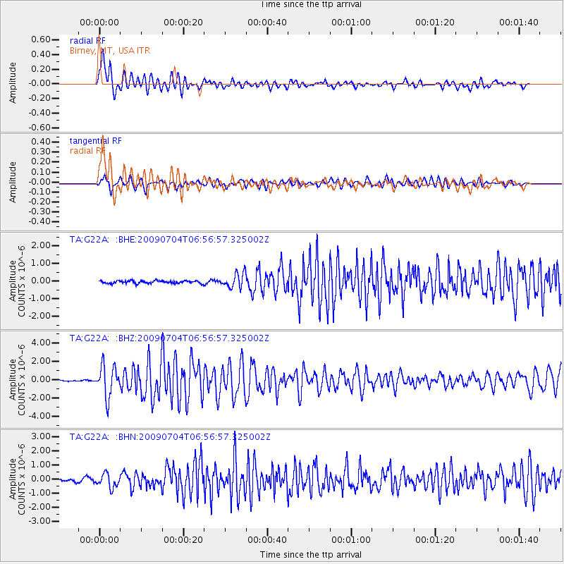
| Radial Match: |
83.497025 % |
| Radial Bump: |
400 |
| Transverse Match: |
76.08723 % |
| Transverse Bump: |
400 |
| SOD ConfigId: |
2648 |
| Insert Time: |
2010-03-06 19:38:08.488 +0000 |
| GWidth: |
2.5 |
| Max Bumps: |
400 |
| Tol: |
0.001 |
|
Signal To Noise
| Channel | StoN | STA | LTA |
| TA:G22A: :BHZ:20090704T06:56:57.325002Z | 19.043888 | 1.7146946E-6 | 9.0039094E-8 |
| TA:G22A: :BHN:20090704T06:56:57.325002Z | 5.379867 | 4.8855867E-7 | 9.081241E-8 |
| TA:G22A: :BHE:20090704T06:56:57.325002Z | 5.7741437 | 4.2607343E-7 | 7.378989E-8 |
| Arrivals |
| Ps | 2.5 SECOND |
| PpPs | 9.1 SECOND |
| PsPs/PpSs | 12 SECOND |


