You are here: Home > Network List > TA - USArray Transportable Network (new EarthScope stations) Stations List
> Station G22A Birney, MT, USA > Earthquake Result Viewer
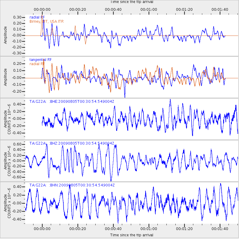
G22A Birney, MT, USA - Earthquake Result Viewer
*The percent match for this event was below the threshold and hence no stack was calculated.
| Earthquake location: |
Southwestern Ryukyu Isl., Japan |
| Earthquake latitude/longitude: |
24.2/125.1 |
| Earthquake time(UTC): |
2009/08/05 (217) 00:17:58 GMT |
| Earthquake Depth: |
25 km |
| Earthquake Magnitude: |
5.9 MB, 5.9 MS, 6.2 MW, 6.1 MW |
| Earthquake Catalog/Contributor: |
WHDF/NEIC |
|
| Network: |
TA USArray Transportable Network (new EarthScope stations) |
| Station: |
G22A Birney, MT, USA |
| Lat/Lon: |
45.22 N/106.29 W |
| Elevation: |
1203 m |
|
| Distance: |
96.5 deg |
| Az: |
33.772 deg |
| Baz: |
314.11 deg |
| Ray Param: |
$rayparam |
*The percent match for this event was below the threshold and hence was not used in the summary stack. |
|
| Radial Match: |
63.6638 % |
| Radial Bump: |
400 |
| Transverse Match: |
64.614105 % |
| Transverse Bump: |
400 |
| SOD ConfigId: |
2622 |
| Insert Time: |
2010-03-06 19:38:29.455 +0000 |
| GWidth: |
2.5 |
| Max Bumps: |
400 |
| Tol: |
0.001 |
|
Signal To Noise
| Channel | StoN | STA | LTA |
| TA:G22A: :BHZ:20090805T00:30:54.549004Z | 1.6290166 | 3.1828367E-7 | 1.9538393E-7 |
| TA:G22A: :BHN:20090805T00:30:54.549004Z | 0.8560388 | 1.3373175E-7 | 1.5622159E-7 |
| TA:G22A: :BHE:20090805T00:30:54.549004Z | 1.1815228 | 1.4470535E-7 | 1.2247361E-7 |
| Arrivals |
| Ps | |
| PpPs | |
| PsPs/PpSs | |


