You are here: Home > Network List > TA - USArray Transportable Network (new EarthScope stations) Stations List
> Station G22A Birney, MT, USA > Earthquake Result Viewer
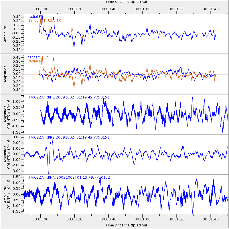
G22A Birney, MT, USA - Earthquake Result Viewer
*The percent match for this event was below the threshold and hence no stack was calculated.
| Earthquake location: |
Tonga Islands |
| Earthquake latitude/longitude: |
-16.3/-173.5 |
| Earthquake time(UTC): |
2009/10/02 (275) 01:07:39 GMT |
| Earthquake Depth: |
8.0 km |
| Earthquake Magnitude: |
6.1 MB, 6.0 MS, 6.1 MW, 6.1 MW |
| Earthquake Catalog/Contributor: |
WHDF/NEIC |
|
| Network: |
TA USArray Transportable Network (new EarthScope stations) |
| Station: |
G22A Birney, MT, USA |
| Lat/Lon: |
45.22 N/106.29 W |
| Elevation: |
1203 m |
|
| Distance: |
86.2 deg |
| Az: |
40.757 deg |
| Baz: |
242.484 deg |
| Ray Param: |
$rayparam |
*The percent match for this event was below the threshold and hence was not used in the summary stack. |
|
| Radial Match: |
64.70925 % |
| Radial Bump: |
400 |
| Transverse Match: |
50.339455 % |
| Transverse Bump: |
400 |
| SOD ConfigId: |
2622 |
| Insert Time: |
2010-03-06 19:38:43.433 +0000 |
| GWidth: |
2.5 |
| Max Bumps: |
400 |
| Tol: |
0.001 |
|
Signal To Noise
| Channel | StoN | STA | LTA |
| TA:G22A: :BHZ:20091002T01:19:49.775015Z | 6.8032846 | 1.0929095E-6 | 1.6064439E-7 |
| TA:G22A: :BHN:20091002T01:19:49.775015Z | 1.3827302 | 4.4467652E-7 | 3.215931E-7 |
| TA:G22A: :BHE:20091002T01:19:49.775015Z | 1.3168005 | 4.6506952E-7 | 3.5318146E-7 |
| Arrivals |
| Ps | |
| PpPs | |
| PsPs/PpSs | |


