You are here: Home > Network List > TA - USArray Transportable Network (new EarthScope stations) Stations List
> Station G22A Birney, MT, USA > Earthquake Result Viewer
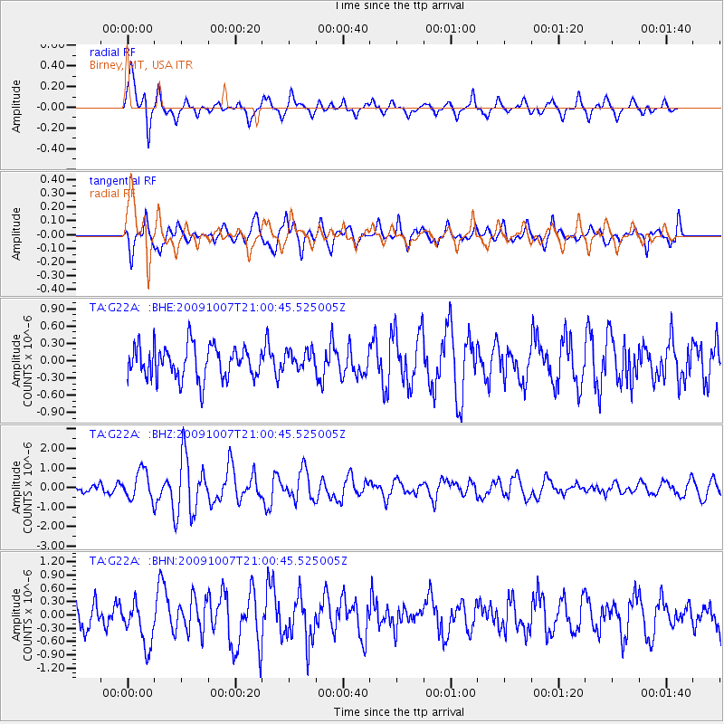
G22A Birney, MT, USA - Earthquake Result Viewer
*The percent match for this event was below the threshold and hence no stack was calculated.
| Earthquake location: |
East Of Severnaya Zemlya |
| Earthquake latitude/longitude: |
81.6/119.5 |
| Earthquake time(UTC): |
2009/10/07 (280) 20:52:13 GMT |
| Earthquake Depth: |
8.0 km |
| Earthquake Magnitude: |
5.7 MB, 5.1 MS, 5.8 MW, 5.8 MW |
| Earthquake Catalog/Contributor: |
WHDF/NEIC |
|
| Network: |
TA USArray Transportable Network (new EarthScope stations) |
| Station: |
G22A Birney, MT, USA |
| Lat/Lon: |
45.22 N/106.29 W |
| Elevation: |
1203 m |
|
| Distance: |
51.2 deg |
| Az: |
40.597 deg |
| Baz: |
352.193 deg |
| Ray Param: |
$rayparam |
*The percent match for this event was below the threshold and hence was not used in the summary stack. |
|
| Radial Match: |
77.973045 % |
| Radial Bump: |
353 |
| Transverse Match: |
74.37531 % |
| Transverse Bump: |
400 |
| SOD ConfigId: |
2622 |
| Insert Time: |
2010-03-06 19:38:46.984 +0000 |
| GWidth: |
2.5 |
| Max Bumps: |
400 |
| Tol: |
0.001 |
|
Signal To Noise
| Channel | StoN | STA | LTA |
| TA:G22A: :BHZ:20091007T21:00:45.525005Z | 5.061511 | 7.420917E-7 | 1.4661465E-7 |
| TA:G22A: :BHN:20091007T21:00:45.525005Z | 1.7209026 | 5.058171E-7 | 2.9392547E-7 |
| TA:G22A: :BHE:20091007T21:00:45.525005Z | 0.5793757 | 1.6327527E-7 | 2.8181242E-7 |
| Arrivals |
| Ps | |
| PpPs | |
| PsPs/PpSs | |


