You are here: Home > Network List > TA - USArray Transportable Network (new EarthScope stations) Stations List
> Station G22A Birney, MT, USA > Earthquake Result Viewer
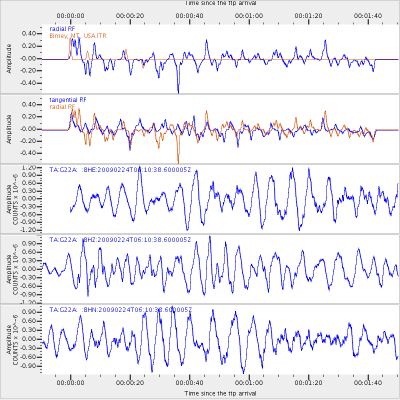
G22A Birney, MT, USA - Earthquake Result Viewer
*The percent match for this event was below the threshold and hence no stack was calculated.
| Earthquake location: |
South Of Mariana Islands |
| Earthquake latitude/longitude: |
13.8/146.3 |
| Earthquake time(UTC): |
2009/02/24 (055) 05:57:59 GMT |
| Earthquake Depth: |
5.0 km |
| Earthquake Magnitude: |
5.7 MB, 5.7 MS, 5.9 MW, 5.8 MW |
| Earthquake Catalog/Contributor: |
WHDF/NEIC |
|
| Network: |
TA USArray Transportable Network (new EarthScope stations) |
| Station: |
G22A Birney, MT, USA |
| Lat/Lon: |
45.22 N/106.29 W |
| Elevation: |
1203 m |
|
| Distance: |
92.2 deg |
| Az: |
42.448 deg |
| Baz: |
291.912 deg |
| Ray Param: |
$rayparam |
*The percent match for this event was below the threshold and hence was not used in the summary stack. |
|
| Radial Match: |
54.181435 % |
| Radial Bump: |
366 |
| Transverse Match: |
63.662846 % |
| Transverse Bump: |
400 |
| SOD ConfigId: |
2658 |
| Insert Time: |
2010-03-06 19:38:53.348 +0000 |
| GWidth: |
2.5 |
| Max Bumps: |
400 |
| Tol: |
0.001 |
|
Signal To Noise
| Channel | StoN | STA | LTA |
| TA:G22A: :BHZ:20090224T06:10:38.600005Z | 2.6708696 | 5.426732E-7 | 2.0318221E-7 |
| TA:G22A: :BHN:20090224T06:10:38.600005Z | 1.6414033 | 3.9322384E-7 | 2.3956562E-7 |
| TA:G22A: :BHE:20090224T06:10:38.600005Z | 0.58165985 | 2.4915926E-7 | 4.2835904E-7 |
| Arrivals |
| Ps | |
| PpPs | |
| PsPs/PpSs | |


