You are here: Home > Network List > TA - USArray Transportable Network (new EarthScope stations) Stations List
> Station G22A Birney, MT, USA > Earthquake Result Viewer
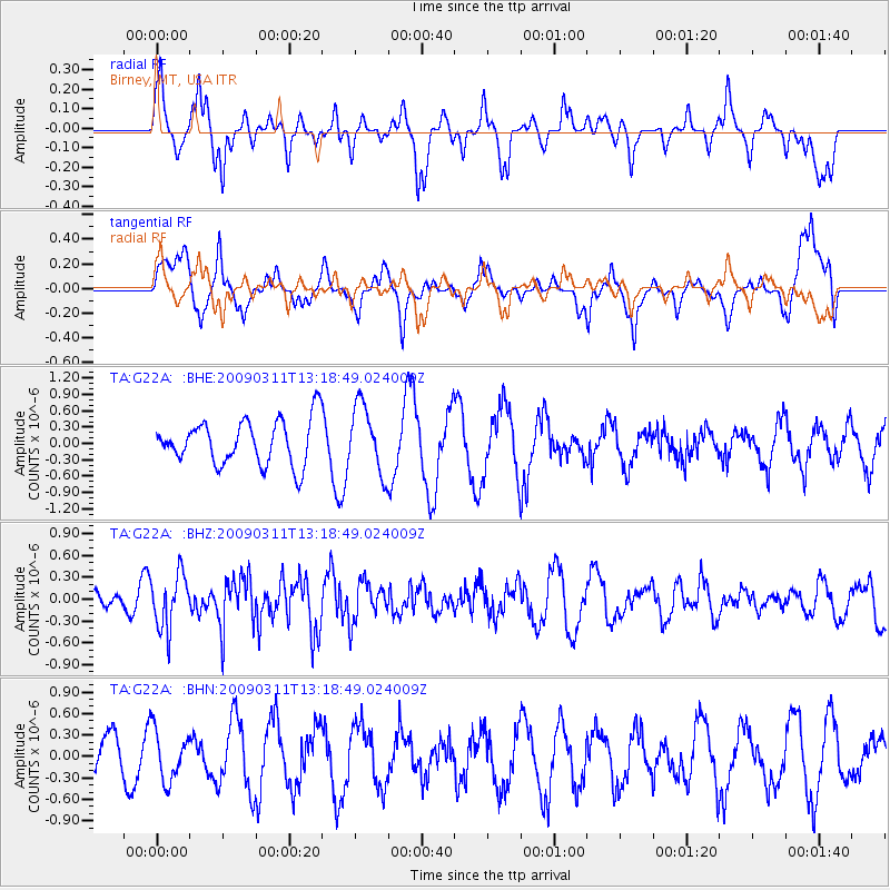
G22A Birney, MT, USA - Earthquake Result Viewer
*The percent match for this event was below the threshold and hence no stack was calculated.
| Earthquake location: |
San Juan Province, Argentina |
| Earthquake latitude/longitude: |
-31.9/-69.2 |
| Earthquake time(UTC): |
2009/03/11 (070) 13:06:53 GMT |
| Earthquake Depth: |
28 km |
| Earthquake Magnitude: |
5.5 MB, 4.8 MS, 5.3 MW, 5.5 ML |
| Earthquake Catalog/Contributor: |
WHDF/NEIC |
|
| Network: |
TA USArray Transportable Network (new EarthScope stations) |
| Station: |
G22A Birney, MT, USA |
| Lat/Lon: |
45.22 N/106.29 W |
| Elevation: |
1203 m |
|
| Distance: |
83.8 deg |
| Az: |
334.605 deg |
| Baz: |
148.923 deg |
| Ray Param: |
$rayparam |
*The percent match for this event was below the threshold and hence was not used in the summary stack. |
|
| Radial Match: |
33.03974 % |
| Radial Bump: |
277 |
| Transverse Match: |
55.214184 % |
| Transverse Bump: |
400 |
| SOD ConfigId: |
2658 |
| Insert Time: |
2010-03-06 19:38:57.191 +0000 |
| GWidth: |
2.5 |
| Max Bumps: |
400 |
| Tol: |
0.001 |
|
Signal To Noise
| Channel | StoN | STA | LTA |
| TA:G22A: :BHZ:20090311T13:18:49.024009Z | 2.2038932 | 3.7277408E-7 | 1.6914345E-7 |
| TA:G22A: :BHN:20090311T13:18:49.024009Z | 1.3101156 | 3.4953422E-7 | 2.6679646E-7 |
| TA:G22A: :BHE:20090311T13:18:49.024009Z | 1.5224931 | 6.1954955E-7 | 4.0693092E-7 |
| Arrivals |
| Ps | |
| PpPs | |
| PsPs/PpSs | |


