You are here: Home > Network List > TA - USArray Transportable Network (new EarthScope stations) Stations List
> Station G22A Birney, MT, USA > Earthquake Result Viewer
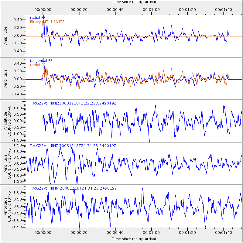
G22A Birney, MT, USA - Earthquake Result Viewer
*The percent match for this event was below the threshold and hence no stack was calculated.
| Earthquake location: |
Near Coast Of Central Chile |
| Earthquake latitude/longitude: |
-32.5/-71.7 |
| Earthquake time(UTC): |
2008/12/18 (353) 21:19:28 GMT |
| Earthquake Depth: |
18 km |
| Earthquake Magnitude: |
5.8 MB, 6.0 MS, 6.2 MW, 6.1 MW |
| Earthquake Catalog/Contributor: |
WHDF/NEIC |
|
| Network: |
TA USArray Transportable Network (new EarthScope stations) |
| Station: |
G22A Birney, MT, USA |
| Lat/Lon: |
45.22 N/106.29 W |
| Elevation: |
1203 m |
|
| Distance: |
83.4 deg |
| Az: |
336.194 deg |
| Baz: |
151.131 deg |
| Ray Param: |
$rayparam |
*The percent match for this event was below the threshold and hence was not used in the summary stack. |
|
| Radial Match: |
54.345634 % |
| Radial Bump: |
400 |
| Transverse Match: |
56.173695 % |
| Transverse Bump: |
400 |
| SOD ConfigId: |
2658 |
| Insert Time: |
2010-03-06 19:39:05.660 +0000 |
| GWidth: |
2.5 |
| Max Bumps: |
400 |
| Tol: |
0.001 |
|
Signal To Noise
| Channel | StoN | STA | LTA |
| TA:G22A: :BHZ:20081218T21:31:23.249019Z | 2.3322556 | 8.307703E-7 | 3.5620894E-7 |
| TA:G22A: :BHN:20081218T21:31:23.249019Z | 0.8400007 | 4.5808682E-7 | 5.45341E-7 |
| TA:G22A: :BHE:20081218T21:31:23.249019Z | 1.294453 | 5.623505E-7 | 4.3443097E-7 |
| Arrivals |
| Ps | |
| PpPs | |
| PsPs/PpSs | |


