You are here: Home > Network List > TA - USArray Transportable Network (new EarthScope stations) Stations List
> Station G22A Birney, MT, USA > Earthquake Result Viewer
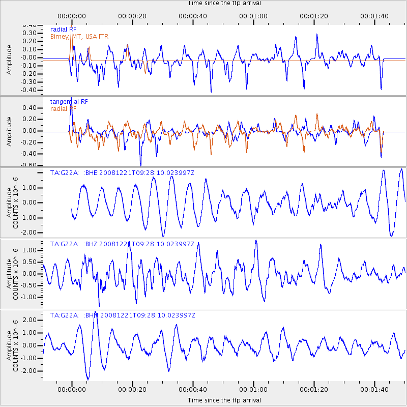
G22A Birney, MT, USA - Earthquake Result Viewer
*The percent match for this event was below the threshold and hence no stack was calculated.
| Earthquake location: |
Off East Coast Of Honshu, Japan |
| Earthquake latitude/longitude: |
36.5/142.3 |
| Earthquake time(UTC): |
2008/12/21 (356) 09:16:44 GMT |
| Earthquake Depth: |
13 km |
| Earthquake Magnitude: |
5.6 MB, 5.7 MS, 5.9 MW, 5.9 MW |
| Earthquake Catalog/Contributor: |
WHDF/NEIC |
|
| Network: |
TA USArray Transportable Network (new EarthScope stations) |
| Station: |
G22A Birney, MT, USA |
| Lat/Lon: |
45.22 N/106.29 W |
| Elevation: |
1203 m |
|
| Distance: |
77.8 deg |
| Az: |
42.327 deg |
| Baz: |
309.891 deg |
| Ray Param: |
$rayparam |
*The percent match for this event was below the threshold and hence was not used in the summary stack. |
|
| Radial Match: |
50.56315 % |
| Radial Bump: |
382 |
| Transverse Match: |
31.820095 % |
| Transverse Bump: |
222 |
| SOD ConfigId: |
2658 |
| Insert Time: |
2010-03-06 19:39:17.418 +0000 |
| GWidth: |
2.5 |
| Max Bumps: |
400 |
| Tol: |
0.001 |
|
Signal To Noise
| Channel | StoN | STA | LTA |
| TA:G22A: :BHZ:20081221T09:28:10.023997Z | 1.3698573 | 4.142244E-7 | 3.0238508E-7 |
| TA:G22A: :BHN:20081221T09:28:10.023997Z | 0.8862023 | 1.0522564E-6 | 1.1873773E-6 |
| TA:G22A: :BHE:20081221T09:28:10.023997Z | 1.6709613 | 1.3807554E-6 | 8.26324E-7 |
| Arrivals |
| Ps | |
| PpPs | |
| PsPs/PpSs | |


