You are here: Home > Network List > TA - USArray Transportable Network (new EarthScope stations) Stations List
> Station F21K Alatna River, AK, USA > Earthquake Result Viewer
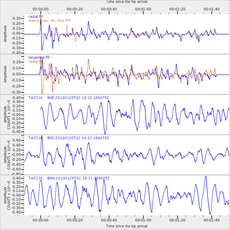
F21K Alatna River, AK, USA - Earthquake Result Viewer
*The percent match for this event was below the threshold and hence no stack was calculated.
| Earthquake location: |
Santa Cruz Islands |
| Earthquake latitude/longitude: |
-10.9/165.9 |
| Earthquake time(UTC): |
2019/01/26 (026) 02:07:23 GMT |
| Earthquake Depth: |
52 km |
| Earthquake Magnitude: |
5.7 Mww |
| Earthquake Catalog/Contributor: |
NEIC PDE/us |
|
| Network: |
TA USArray Transportable Network (new EarthScope stations) |
| Station: |
F21K Alatna River, AK, USA |
| Lat/Lon: |
67.22 N/153.48 W |
| Elevation: |
597 m |
|
| Distance: |
83.2 deg |
| Az: |
14.774 deg |
| Baz: |
220.04 deg |
| Ray Param: |
$rayparam |
*The percent match for this event was below the threshold and hence was not used in the summary stack. |
|
| Radial Match: |
59.414482 % |
| Radial Bump: |
400 |
| Transverse Match: |
66.26938 % |
| Transverse Bump: |
364 |
| SOD ConfigId: |
13570011 |
| Insert Time: |
2019-05-02 09:24:55.113 +0000 |
| GWidth: |
2.5 |
| Max Bumps: |
400 |
| Tol: |
0.001 |
|
Signal To Noise
| Channel | StoN | STA | LTA |
| TA:F21K: :BHZ:20190126T02:19:13.199976Z | 1.4163634 | 3.5526705E-7 | 2.5083045E-7 |
| TA:F21K: :BHN:20190126T02:19:13.199976Z | 1.2887068 | 2.300615E-7 | 1.785212E-7 |
| TA:F21K: :BHE:20190126T02:19:13.199976Z | 0.6972456 | 1.08451836E-7 | 1.5554323E-7 |
| Arrivals |
| Ps | |
| PpPs | |
| PsPs/PpSs | |


