You are here: Home > Network List > TA - USArray Transportable Network (new EarthScope stations) Stations List
> Station G22A Birney, MT, USA > Earthquake Result Viewer
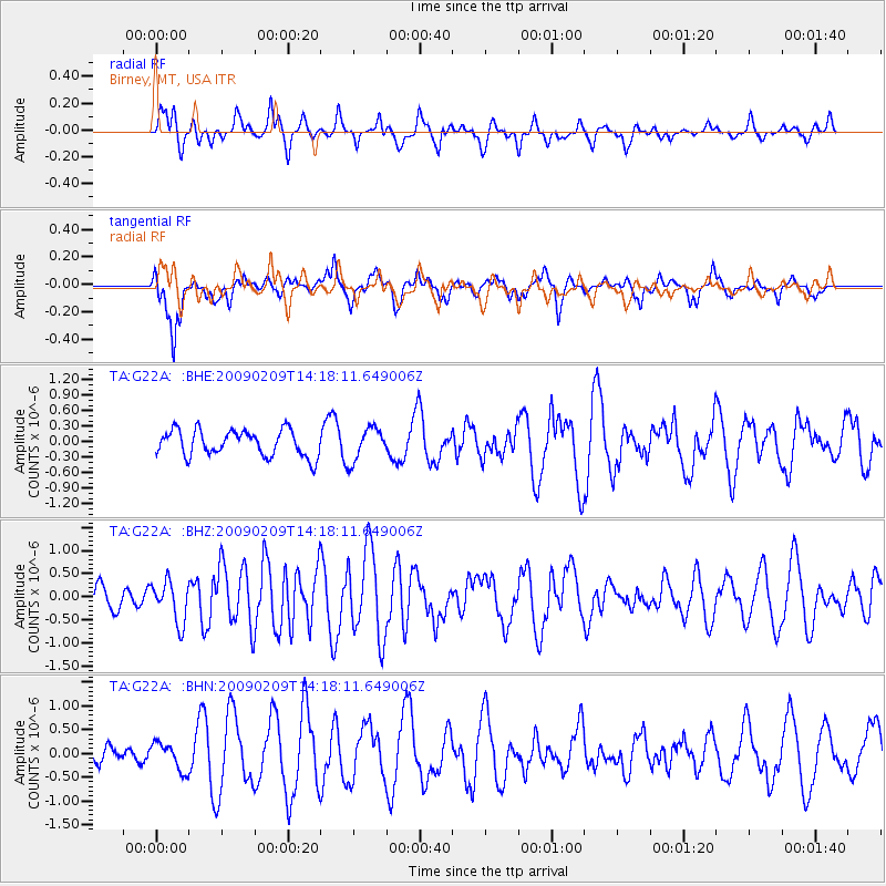
G22A Birney, MT, USA - Earthquake Result Viewer
*The percent match for this event was below the threshold and hence no stack was calculated.
| Earthquake location: |
Near Coast Of Northern Peru |
| Earthquake latitude/longitude: |
-6.6/-81.2 |
| Earthquake time(UTC): |
2009/02/09 (040) 14:09:02 GMT |
| Earthquake Depth: |
15 km |
| Earthquake Magnitude: |
5.5 MB, 5.5 MS, 6.0 MW, 5.9 MW |
| Earthquake Catalog/Contributor: |
WHDF/NEIC |
|
| Network: |
TA USArray Transportable Network (new EarthScope stations) |
| Station: |
G22A Birney, MT, USA |
| Lat/Lon: |
45.22 N/106.29 W |
| Elevation: |
1203 m |
|
| Distance: |
56.3 deg |
| Az: |
338.834 deg |
| Baz: |
149.498 deg |
| Ray Param: |
$rayparam |
*The percent match for this event was below the threshold and hence was not used in the summary stack. |
|
| Radial Match: |
42.82148 % |
| Radial Bump: |
338 |
| Transverse Match: |
60.046738 % |
| Transverse Bump: |
400 |
| SOD ConfigId: |
2658 |
| Insert Time: |
2010-03-06 19:39:27.396 +0000 |
| GWidth: |
2.5 |
| Max Bumps: |
400 |
| Tol: |
0.001 |
|
Signal To Noise
| Channel | StoN | STA | LTA |
| TA:G22A: :BHZ:20090209T14:18:11.649006Z | 2.2625563 | 4.4382986E-7 | 1.9616301E-7 |
| TA:G22A: :BHN:20090209T14:18:11.649006Z | 1.9206288 | 2.8771288E-7 | 1.498014E-7 |
| TA:G22A: :BHE:20090209T14:18:11.649006Z | 1.268775 | 3.1683322E-7 | 2.4971584E-7 |
| Arrivals |
| Ps | |
| PpPs | |
| PsPs/PpSs | |


