You are here: Home > Network List > AG - Arkansas Seismic Network Stations List
> Station WHAR Woolly Hollow State Park,AR > Earthquake Result Viewer
WHAR Woolly Hollow State Park,AR - Earthquake Result Viewer
| Earthquake location: |
Northern Peru |
| Earthquake latitude/longitude: |
-5.6/-77.0 |
| Earthquake time(UTC): |
2016/09/10 (254) 10:08:20 GMT |
| Earthquake Depth: |
114 km |
| Earthquake Magnitude: |
6.0 MB |
| Earthquake Catalog/Contributor: |
NEIC PDE/NEIC ALERT |
|
| Network: |
AG Arkansas Seismic Network |
| Station: |
WHAR Woolly Hollow State Park,AR |
| Lat/Lon: |
35.29 N/92.29 W |
| Elevation: |
184 m |
|
| Distance: |
43.1 deg |
| Az: |
341.567 deg |
| Baz: |
157.375 deg |
| Ray Param: |
0.07233055 |
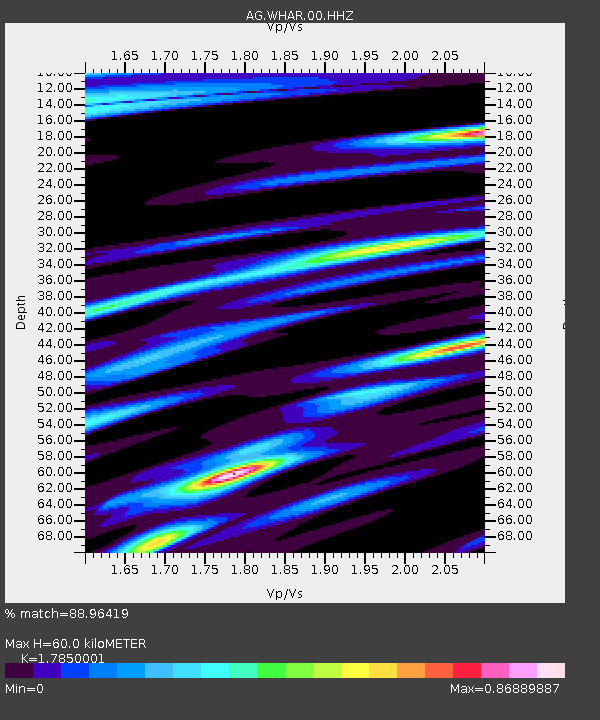
| Estimated Moho Depth: |
60.0 km |
| Estimated Crust Vp/Vs: |
1.79 |
| Assumed Crust Vp: |
6.498 km/s |
| Estimated Crust Vs: |
3.64 km/s |
| Estimated Crust Poisson's Ratio: |
0.27 |
|
| Radial Match: |
88.96419 % |
| Radial Bump: |
245 |
| Transverse Match: |
75.53643 % |
| Transverse Bump: |
396 |
| SOD ConfigId: |
1634031 |
| Insert Time: |
2016-09-24 10:09:43.885 +0000 |
| GWidth: |
2.5 |
| Max Bumps: |
400 |
| Tol: |
0.001 |
|

Signal To Noise
| Channel | StoN | STA | LTA |
| AG:WHAR:00:HHZ:20160910T10:15:38.679993Z | 31.279182 | 2.3890434E-6 | 7.6378065E-8 |
| AG:WHAR:00:HHN:20160910T10:15:38.679993Z | 16.636585 | 1.3219569E-6 | 7.946084E-8 |
| AG:WHAR:00:HHE:20160910T10:15:38.679993Z | 6.20744 | 6.82325E-7 | 1.09920514E-7 |
| Arrivals |
| Ps | 7.8 SECOND |
| PpPs | 24 SECOND |
| PsPs/PpSs | 32 SECOND |


