You are here: Home > Network List > TS - TERRAscope (Southern California Seismic Network) Stations List
> Station CALB Calabasas, California, USA > Earthquake Result Viewer
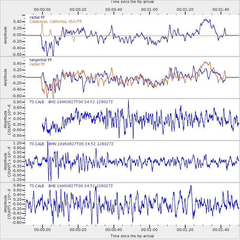
CALB Calabasas, California, USA - Earthquake Result Viewer
*The percent match for this event was below the threshold and hence no stack was calculated.
| Earthquake location: |
South Of Fiji Islands |
| Earthquake latitude/longitude: |
-22.6/-179.8 |
| Earthquake time(UTC): |
1996/08/27 (240) 06:24:07 GMT |
| Earthquake Depth: |
575 km |
| Earthquake Magnitude: |
5.6 MB, 6.0 UNKNOWN, 5.5 MB |
| Earthquake Catalog/Contributor: |
WHDF/NEIC |
|
| Network: |
TS TERRAscope (Southern California Seismic Network) |
| Station: |
CALB Calabasas, California, USA |
| Lat/Lon: |
34.14 N/118.63 W |
| Elevation: |
0.0 m |
|
| Distance: |
81.0 deg |
| Az: |
47.36 deg |
| Baz: |
235.067 deg |
| Ray Param: |
$rayparam |
*The percent match for this event was below the threshold and hence was not used in the summary stack. |
|
| Radial Match: |
48.76094 % |
| Radial Bump: |
400 |
| Transverse Match: |
51.765198 % |
| Transverse Bump: |
400 |
| SOD ConfigId: |
4480 |
| Insert Time: |
2010-02-26 14:04:19.653 +0000 |
| GWidth: |
2.5 |
| Max Bumps: |
400 |
| Tol: |
0.001 |
|
Signal To Noise
| Channel | StoN | STA | LTA |
| TS:CALB: :BHN:19960827T06:34:52.128027Z | 2.4770124 | 5.058271E-7 | 2.0420853E-7 |
| TS:CALB: :BHE:19960827T06:34:52.128027Z | 0.88490695 | 2.418342E-7 | 2.732877E-7 |
| TS:CALB: :BHZ:19960827T06:34:52.128027Z | 0.92153156 | 3.119337E-7 | 3.3849486E-7 |
| Arrivals |
| Ps | |
| PpPs | |
| PsPs/PpSs | |


