You are here: Home > Network List > AV - Alaska Volcano Observatory Stations List
> Station SPCR Ckakachatna River, Mount Spurr, Alaska > Earthquake Result Viewer
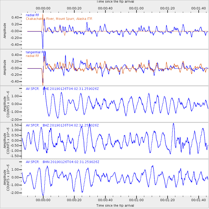
SPCR Ckakachatna River, Mount Spurr, Alaska - Earthquake Result Viewer
*The percent match for this event was below the threshold and hence no stack was calculated.
| Earthquake location: |
Solomon Islands |
| Earthquake latitude/longitude: |
-7.0/156.3 |
| Earthquake time(UTC): |
2019/01/26 (026) 03:51:38 GMT |
| Earthquake Depth: |
358 km |
| Earthquake Magnitude: |
6.2 Mww |
| Earthquake Catalog/Contributor: |
NEIC PDE/us |
|
| Network: |
AV Alaska Volcano Observatory |
| Station: |
SPCR Ckakachatna River, Mount Spurr, Alaska |
| Lat/Lon: |
61.20 N/152.21 W |
| Elevation: |
984 m |
|
| Distance: |
78.9 deg |
| Az: |
22.72 deg |
| Baz: |
232.346 deg |
| Ray Param: |
$rayparam |
*The percent match for this event was below the threshold and hence was not used in the summary stack. |
|
| Radial Match: |
52.6021 % |
| Radial Bump: |
400 |
| Transverse Match: |
61.825634 % |
| Transverse Bump: |
400 |
| SOD ConfigId: |
13570011 |
| Insert Time: |
2019-05-02 09:27:44.970 +0000 |
| GWidth: |
2.5 |
| Max Bumps: |
400 |
| Tol: |
0.001 |
|
Signal To Noise
| Channel | StoN | STA | LTA |
| AV:SPCR: :BHZ:20190126T04:02:31.259026Z | 1.0553672 | 7.9101267E-7 | 7.495142E-7 |
| AV:SPCR: :BHN:20190126T04:02:31.259026Z | 2.179315 | 1.3531702E-6 | 6.209154E-7 |
| AV:SPCR: :BHE:20190126T04:02:31.259026Z | 0.50664616 | 5.121449E-7 | 1.0108532E-6 |
| Arrivals |
| Ps | |
| PpPs | |
| PsPs/PpSs | |


