You are here: Home > Network List > CN - Canadian National Seismograph Network Stations List
> Station INK INUVIK, NT > Earthquake Result Viewer
INK INUVIK, NT - Earthquake Result Viewer
*The percent match for this event was below the threshold and hence no stack was calculated.
| Earthquake location: |
Solomon Islands |
| Earthquake latitude/longitude: |
-7.0/156.3 |
| Earthquake time(UTC): |
2019/01/26 (026) 03:51:38 GMT |
| Earthquake Depth: |
358 km |
| Earthquake Magnitude: |
6.2 Mww |
| Earthquake Catalog/Contributor: |
NEIC PDE/us |
|
| Network: |
CN Canadian National Seismograph Network |
| Station: |
INK INUVIK, NT |
| Lat/Lon: |
68.31 N/133.53 W |
| Elevation: |
44 m |
|
| Distance: |
89.3 deg |
| Az: |
20.475 deg |
| Baz: |
249.052 deg |
| Ray Param: |
$rayparam |
*The percent match for this event was below the threshold and hence was not used in the summary stack. |
|
| Radial Match: |
53.522076 % |
| Radial Bump: |
372 |
| Transverse Match: |
62.075947 % |
| Transverse Bump: |
400 |
| SOD ConfigId: |
13570011 |
| Insert Time: |
2019-05-02 09:29:12.359 +0000 |
| GWidth: |
2.5 |
| Max Bumps: |
400 |
| Tol: |
0.001 |
|
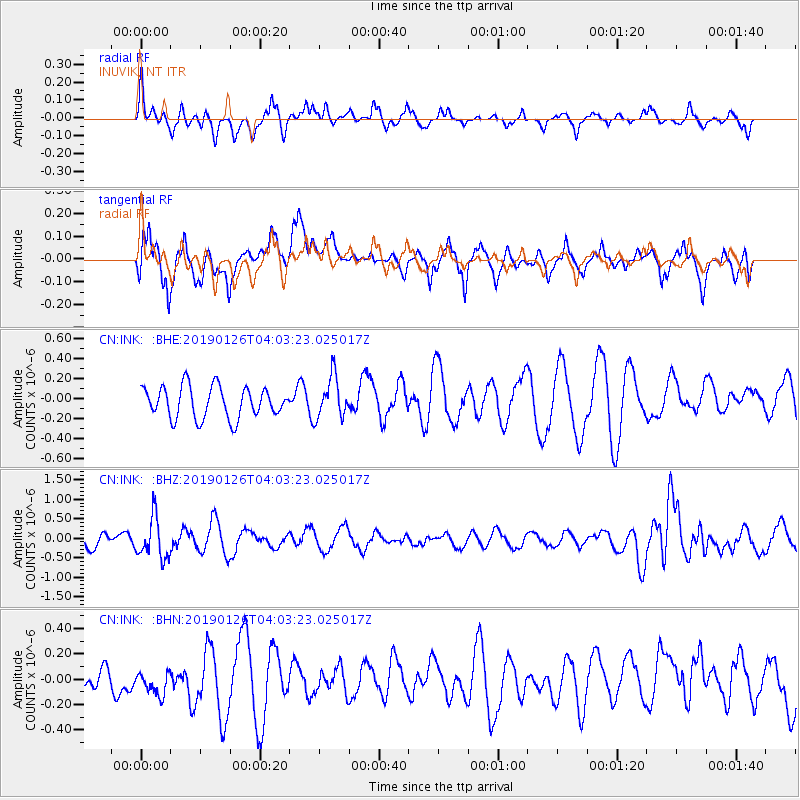
Signal To Noise
| Channel | StoN | STA | LTA |
| CN:INK: :BHZ:20190126T04:03:23.025017Z | 2.6457806 | 5.308535E-7 | 2.0064155E-7 |
| CN:INK: :BHN:20190126T04:03:23.025017Z | 0.60546327 | 1.03743346E-7 | 1.713454E-7 |
| CN:INK: :BHE:20190126T04:03:23.025017Z | 1.3128966 | 2.0646002E-7 | 1.5725534E-7 |
| Arrivals |
| Ps | |
| PpPs | |
| PsPs/PpSs | |


