You are here: Home > Network List > TA - USArray Transportable Network (new EarthScope stations) Stations List
> Station G23A Biddle, MT, USA > Earthquake Result Viewer
G23A Biddle, MT, USA - Earthquake Result Viewer
| Earthquake location: |
South Of Panama |
| Earthquake latitude/longitude: |
5.7/-82.8 |
| Earthquake time(UTC): |
2009/03/12 (071) 23:23:34 GMT |
| Earthquake Depth: |
9.0 km |
| Earthquake Magnitude: |
6.1 MB, 5.9 MS, 6.3 MW, 6.2 MW |
| Earthquake Catalog/Contributor: |
WHDF/NEIC |
|
| Network: |
TA USArray Transportable Network (new EarthScope stations) |
| Station: |
G23A Biddle, MT, USA |
| Lat/Lon: |
45.20 N/105.39 W |
| Elevation: |
1064 m |
|
| Distance: |
44.0 deg |
| Az: |
336.963 deg |
| Baz: |
146.577 deg |
| Ray Param: |
0.072173044 |
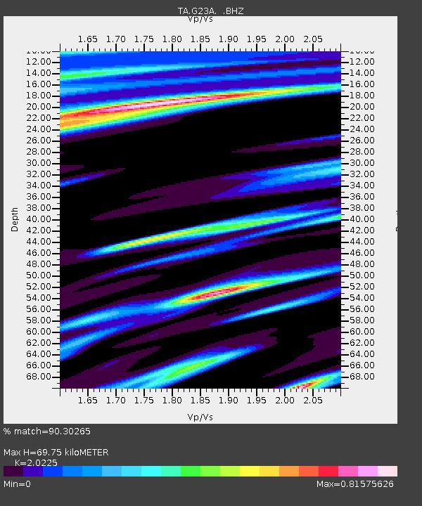
| Estimated Moho Depth: |
69.75 km |
| Estimated Crust Vp/Vs: |
2.02 |
| Assumed Crust Vp: |
6.242 km/s |
| Estimated Crust Vs: |
3.086 km/s |
| Estimated Crust Poisson's Ratio: |
0.34 |
|
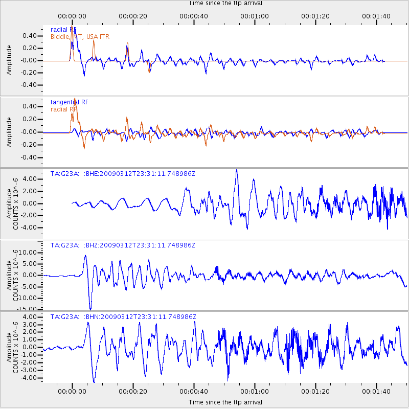
| Radial Match: |
90.30265 % |
| Radial Bump: |
382 |
| Transverse Match: |
72.94825 % |
| Transverse Bump: |
400 |
| SOD ConfigId: |
2658 |
| Insert Time: |
2010-03-06 19:39:47.074 +0000 |
| GWidth: |
2.5 |
| Max Bumps: |
400 |
| Tol: |
0.001 |
|
Signal To Noise
| Channel | StoN | STA | LTA |
| TA:G23A: :BHZ:20090312T23:31:11.748986Z | 14.716539 | 3.3788356E-6 | 2.2959445E-7 |
| TA:G23A: :BHN:20090312T23:31:11.748986Z | 2.2709434 | 7.219946E-7 | 3.1792715E-7 |
| TA:G23A: :BHE:20090312T23:31:11.748986Z | 1.576668 | 7.4623017E-7 | 4.732957E-7 |
| Arrivals |
| Ps | 12 SECOND |
| PpPs | 32 SECOND |
| PsPs/PpSs | 44 SECOND |


