You are here: Home > Network List > TA - USArray Transportable Network (new EarthScope stations) Stations List
> Station G23A Biddle, MT, USA > Earthquake Result Viewer
G23A Biddle, MT, USA - Earthquake Result Viewer
| Earthquake location: |
Southern Peru |
| Earthquake latitude/longitude: |
-15.0/-70.4 |
| Earthquake time(UTC): |
2009/07/12 (193) 06:12:47 GMT |
| Earthquake Depth: |
199 km |
| Earthquake Magnitude: |
5.7 MB, 6.1 MW, 6.1 MW |
| Earthquake Catalog/Contributor: |
WHDF/NEIC |
|
| Network: |
TA USArray Transportable Network (new EarthScope stations) |
| Station: |
G23A Biddle, MT, USA |
| Lat/Lon: |
45.20 N/105.39 W |
| Elevation: |
1064 m |
|
| Distance: |
67.8 deg |
| Az: |
334.066 deg |
| Baz: |
143.298 deg |
| Ray Param: |
0.056139927 |
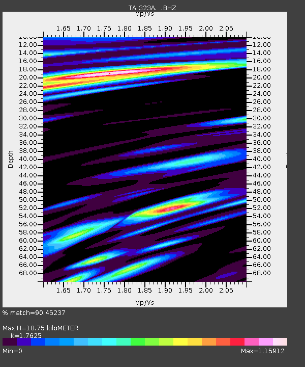
| Estimated Moho Depth: |
18.75 km |
| Estimated Crust Vp/Vs: |
1.76 |
| Assumed Crust Vp: |
6.242 km/s |
| Estimated Crust Vs: |
3.542 km/s |
| Estimated Crust Poisson's Ratio: |
0.26 |
|
| Radial Match: |
90.45237 % |
| Radial Bump: |
400 |
| Transverse Match: |
77.107124 % |
| Transverse Bump: |
400 |
| SOD ConfigId: |
2648 |
| Insert Time: |
2010-03-06 19:39:58.628 +0000 |
| GWidth: |
2.5 |
| Max Bumps: |
400 |
| Tol: |
0.001 |
|
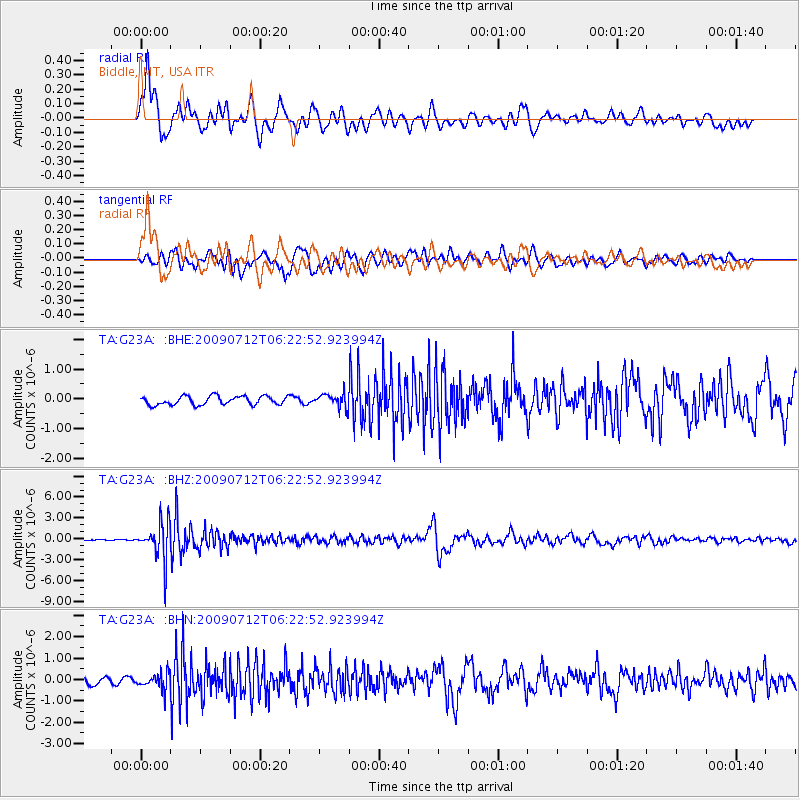
Signal To Noise
| Channel | StoN | STA | LTA |
| TA:G23A: :BHZ:20090712T06:22:52.923994Z | 31.490728 | 2.7060296E-6 | 8.593099E-8 |
| TA:G23A: :BHN:20090712T06:22:52.923994Z | 2.3030226 | 3.887175E-7 | 1.6878579E-7 |
| TA:G23A: :BHE:20090712T06:22:52.923994Z | 1.6114496 | 2.3473771E-7 | 1.4566866E-7 |
| Arrivals |
| Ps | 2.4 SECOND |
| PpPs | 8.0 SECOND |
| PsPs/PpSs | 10 SECOND |


