You are here: Home > Network List > TA - USArray Transportable Network (new EarthScope stations) Stations List
> Station G23A Biddle, MT, USA > Earthquake Result Viewer
G23A Biddle, MT, USA - Earthquake Result Viewer
| Earthquake location: |
Kuril Islands |
| Earthquake latitude/longitude: |
46.0/151.5 |
| Earthquake time(UTC): |
2009/04/07 (097) 04:23:33 GMT |
| Earthquake Depth: |
31 km |
| Earthquake Magnitude: |
6.5 MB, 6.8 MS, 6.9 MW, 6.9 MW |
| Earthquake Catalog/Contributor: |
WHDF/NEIC |
|
| Network: |
TA USArray Transportable Network (new EarthScope stations) |
| Station: |
G23A Biddle, MT, USA |
| Lat/Lon: |
45.20 N/105.39 W |
| Elevation: |
1064 m |
|
| Distance: |
66.7 deg |
| Az: |
48.599 deg |
| Baz: |
312.361 deg |
| Ray Param: |
0.05742248 |
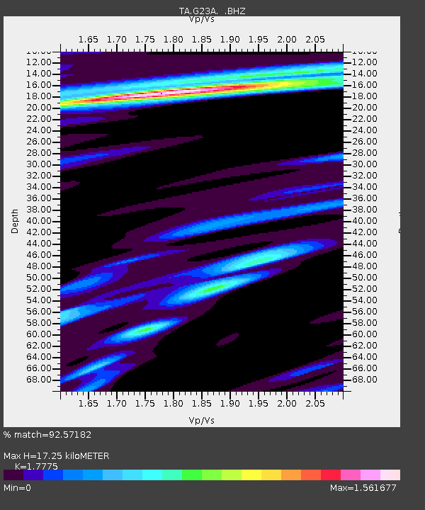
| Estimated Moho Depth: |
17.25 km |
| Estimated Crust Vp/Vs: |
1.78 |
| Assumed Crust Vp: |
6.242 km/s |
| Estimated Crust Vs: |
3.512 km/s |
| Estimated Crust Poisson's Ratio: |
0.27 |
|
| Radial Match: |
92.57182 % |
| Radial Bump: |
400 |
| Transverse Match: |
66.62198 % |
| Transverse Bump: |
400 |
| SOD ConfigId: |
2658 |
| Insert Time: |
2010-03-06 19:40:04.100 +0000 |
| GWidth: |
2.5 |
| Max Bumps: |
400 |
| Tol: |
0.001 |
|
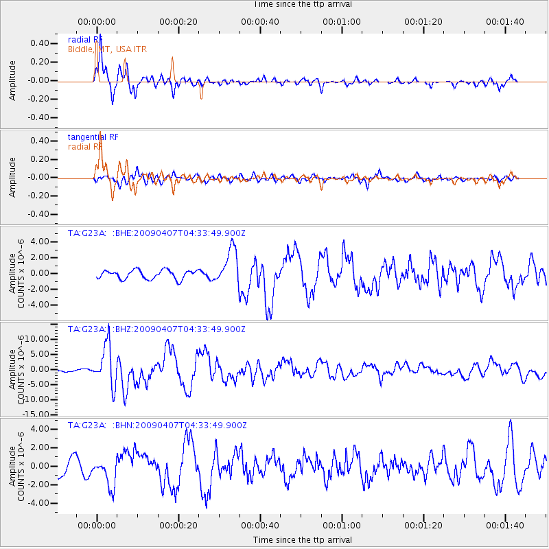
Signal To Noise
| Channel | StoN | STA | LTA |
| TA:G23A: :BHZ:20090407T04:33:49.900Z | 17.73416 | 6.882155E-6 | 3.8807335E-7 |
| TA:G23A: :BHN:20090407T04:33:49.900Z | 1.9850738 | 1.5913372E-6 | 8.016514E-7 |
| TA:G23A: :BHE:20090407T04:33:49.900Z | 4.2123475 | 2.359617E-6 | 5.601667E-7 |
| Arrivals |
| Ps | 2.2 SECOND |
| PpPs | 7.4 SECOND |
| PsPs/PpSs | 9.6 SECOND |


