You are here: Home > Network List > TA - USArray Transportable Network (new EarthScope stations) Stations List
> Station D17K Noatak River, AK, USA > Earthquake Result Viewer
D17K Noatak River, AK, USA - Earthquake Result Viewer
| Earthquake location: |
Solomon Islands |
| Earthquake latitude/longitude: |
-7.0/156.3 |
| Earthquake time(UTC): |
2019/01/26 (026) 03:51:38 GMT |
| Earthquake Depth: |
358 km |
| Earthquake Magnitude: |
6.2 Mww |
| Earthquake Catalog/Contributor: |
NEIC PDE/us |
|
| Network: |
TA USArray Transportable Network (new EarthScope stations) |
| Station: |
D17K Noatak River, AK, USA |
| Lat/Lon: |
67.70 N/163.08 W |
| Elevation: |
172 m |
|
| Distance: |
79.9 deg |
| Az: |
14.621 deg |
| Baz: |
221.032 deg |
| Ray Param: |
0.047671396 |
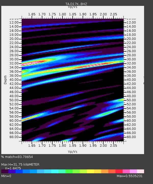
| Estimated Moho Depth: |
31.75 km |
| Estimated Crust Vp/Vs: |
1.65 |
| Assumed Crust Vp: |
6.276 km/s |
| Estimated Crust Vs: |
3.809 km/s |
| Estimated Crust Poisson's Ratio: |
0.21 |
|
| Radial Match: |
83.78654 % |
| Radial Bump: |
291 |
| Transverse Match: |
57.3276 % |
| Transverse Bump: |
358 |
| SOD ConfigId: |
13570011 |
| Insert Time: |
2019-05-02 09:31:23.665 +0000 |
| GWidth: |
2.5 |
| Max Bumps: |
400 |
| Tol: |
0.001 |
|

Signal To Noise
| Channel | StoN | STA | LTA |
| TA:D17K: :BHZ:20190126T04:02:36.749993Z | 7.934893 | 5.7967424E-7 | 7.305382E-8 |
| TA:D17K: :BHN:20190126T04:02:36.749993Z | 2.527371 | 2.618881E-7 | 1.0362076E-7 |
| TA:D17K: :BHE:20190126T04:02:36.749993Z | 1.6281081 | 1.4762988E-7 | 9.067572E-8 |
| Arrivals |
| Ps | 3.4 SECOND |
| PpPs | 13 SECOND |
| PsPs/PpSs | 16 SECOND |


