You are here: Home > Network List > TA - USArray Transportable Network (new EarthScope stations) Stations List
> Station G16K Koyuk River, AK, USA > Earthquake Result Viewer
G16K Koyuk River, AK, USA - Earthquake Result Viewer

| Earthquake location: |
Solomon Islands |
| Earthquake latitude/longitude: |
-7.0/156.3 |
| Earthquake time(UTC): |
2019/01/26 (026) 03:51:38 GMT |
| Earthquake Depth: |
358 km |
| Earthquake Magnitude: |
6.2 Mww |
| Earthquake Catalog/Contributor: |
NEIC PDE/us |
|
| Network: |
TA USArray Transportable Network (new EarthScope stations) |
| Station: |
G16K Koyuk River, AK, USA |
| Lat/Lon: |
65.39 N/162.35 W |
| Elevation: |
169 m |
|
| Distance: |
78.4 deg |
| Az: |
16.406 deg |
| Baz: |
222.036 deg |
| Ray Param: |
0.048703045 |
| Estimated Moho Depth: |
32.0 km |
| Estimated Crust Vp/Vs: |
1.73 |
| Assumed Crust Vp: |
6.276 km/s |
| Estimated Crust Vs: |
3.622 km/s |
| Estimated Crust Poisson's Ratio: |
0.25 |
|
| Radial Match: |
83.45057 % |
| Radial Bump: |
365 |
| Transverse Match: |
64.63324 % |
| Transverse Bump: |
400 |
| SOD ConfigId: |
13570011 |
| Insert Time: |
2019-05-02 09:31:46.675 +0000 |
| GWidth: |
2.5 |
| Max Bumps: |
400 |
| Tol: |
0.001 |
|
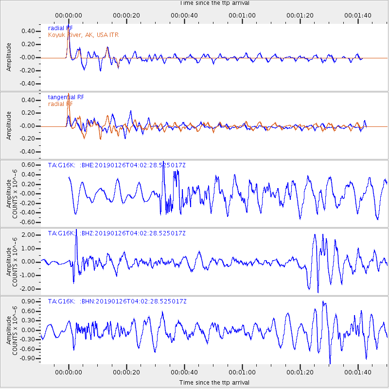
Signal To Noise
| Channel | StoN | STA | LTA |
| TA:G16K: :BHZ:20190126T04:02:28.525017Z | 3.165961 | 8.2505176E-7 | 2.6060073E-7 |
| TA:G16K: :BHN:20190126T04:02:28.525017Z | 1.929149 | 2.3601204E-7 | 1.2233997E-7 |
| TA:G16K: :BHE:20190126T04:02:28.525017Z | 1.5922731 | 2.611013E-7 | 1.6398023E-7 |
| Arrivals |
| Ps | 3.8 SECOND |
| PpPs | 14 SECOND |
| PsPs/PpSs | 17 SECOND |


