You are here: Home > Network List > TA - USArray Transportable Network (new EarthScope stations) Stations List
> Station H16K Elim, AK, USA > Earthquake Result Viewer
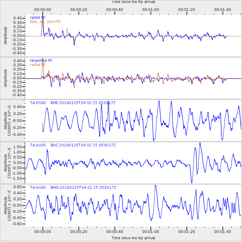
H16K Elim, AK, USA - Earthquake Result Viewer
*The percent match for this event was below the threshold and hence no stack was calculated.
| Earthquake location: |
Solomon Islands |
| Earthquake latitude/longitude: |
-7.0/156.3 |
| Earthquake time(UTC): |
2019/01/26 (026) 03:51:38 GMT |
| Earthquake Depth: |
358 km |
| Earthquake Magnitude: |
6.2 Mww |
| Earthquake Catalog/Contributor: |
NEIC PDE/us |
|
| Network: |
TA USArray Transportable Network (new EarthScope stations) |
| Station: |
H16K Elim, AK, USA |
| Lat/Lon: |
64.64 N/162.24 W |
| Elevation: |
216 m |
|
| Distance: |
77.8 deg |
| Az: |
16.964 deg |
| Baz: |
222.256 deg |
| Ray Param: |
$rayparam |
*The percent match for this event was below the threshold and hence was not used in the summary stack. |
|
| Radial Match: |
72.390724 % |
| Radial Bump: |
350 |
| Transverse Match: |
58.536854 % |
| Transverse Bump: |
362 |
| SOD ConfigId: |
13570011 |
| Insert Time: |
2019-05-02 09:31:52.151 +0000 |
| GWidth: |
2.5 |
| Max Bumps: |
400 |
| Tol: |
0.001 |
|
Signal To Noise
| Channel | StoN | STA | LTA |
| TA:H16K: :BHZ:20190126T04:02:25.650017Z | 3.033841 | 5.8588967E-7 | 1.9311813E-7 |
| TA:H16K: :BHN:20190126T04:02:25.650017Z | 1.1466104 | 2.025834E-7 | 1.7668025E-7 |
| TA:H16K: :BHE:20190126T04:02:25.650017Z | 1.4044808 | 2.7347508E-7 | 1.9471614E-7 |
| Arrivals |
| Ps | |
| PpPs | |
| PsPs/PpSs | |


