You are here: Home > Network List > PS - Pacific21 Stations List
> Station PSI Parapat, Indonesia > Earthquake Result Viewer
PSI Parapat, Indonesia - Earthquake Result Viewer
| Earthquake location: |
Aru Islands Region, Indonesia |
| Earthquake latitude/longitude: |
-5.5/133.8 |
| Earthquake time(UTC): |
2019/01/26 (026) 08:12:48 GMT |
| Earthquake Depth: |
10 km |
| Earthquake Magnitude: |
5.8 Mww |
| Earthquake Catalog/Contributor: |
NEIC PDE/us |
|
| Network: |
PS Pacific21 |
| Station: |
PSI Parapat, Indonesia |
| Lat/Lon: |
2.69 N/98.92 E |
| Elevation: |
987 m |
|
| Distance: |
35.7 deg |
| Az: |
282.293 deg |
| Baz: |
103.166 deg |
| Ray Param: |
0.077061996 |
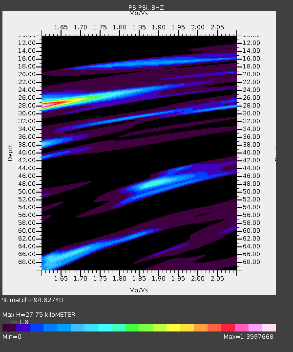
| Estimated Moho Depth: |
27.75 km |
| Estimated Crust Vp/Vs: |
1.60 |
| Assumed Crust Vp: |
6.468 km/s |
| Estimated Crust Vs: |
4.042 km/s |
| Estimated Crust Poisson's Ratio: |
0.18 |
|
| Radial Match: |
94.62748 % |
| Radial Bump: |
366 |
| Transverse Match: |
65.32402 % |
| Transverse Bump: |
400 |
| SOD ConfigId: |
13570011 |
| Insert Time: |
2019-05-02 09:37:05.881 +0000 |
| GWidth: |
2.5 |
| Max Bumps: |
400 |
| Tol: |
0.001 |
|
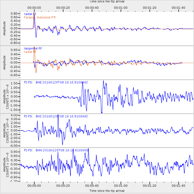
Signal To Noise
| Channel | StoN | STA | LTA |
| PS:PSI: :BHZ:20190126T08:19:16.810999Z | 10.183092 | 1.0499208E-6 | 1.0310433E-7 |
| PS:PSI: :BHN:20190126T08:19:16.810999Z | 2.1226978 | 3.512709E-7 | 1.6548324E-7 |
| PS:PSI: :BHE:20190126T08:19:16.810999Z | 9.236087 | 6.9650343E-7 | 7.5411094E-8 |
| Arrivals |
| Ps | 2.8 SECOND |
| PpPs | 10 SECOND |
| PsPs/PpSs | 13 SECOND |


