You are here: Home > Network List > TA - USArray Transportable Network (new EarthScope stations) Stations List
> Station D23K Nanushuk River, AK USA > Earthquake Result Viewer
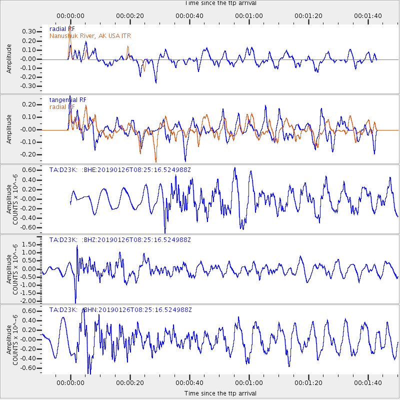
D23K Nanushuk River, AK USA - Earthquake Result Viewer
*The percent match for this event was below the threshold and hence no stack was calculated.
| Earthquake location: |
Aru Islands Region, Indonesia |
| Earthquake latitude/longitude: |
-5.5/133.8 |
| Earthquake time(UTC): |
2019/01/26 (026) 08:12:48 GMT |
| Earthquake Depth: |
10 km |
| Earthquake Magnitude: |
5.8 Mww |
| Earthquake Catalog/Contributor: |
NEIC PDE/us |
|
| Network: |
TA USArray Transportable Network (new EarthScope stations) |
| Station: |
D23K Nanushuk River, AK USA |
| Lat/Lon: |
68.97 N/150.68 W |
| Elevation: |
406 m |
|
| Distance: |
89.9 deg |
| Az: |
20.464 deg |
| Baz: |
254.581 deg |
| Ray Param: |
$rayparam |
*The percent match for this event was below the threshold and hence was not used in the summary stack. |
|
| Radial Match: |
44.919617 % |
| Radial Bump: |
400 |
| Transverse Match: |
53.337933 % |
| Transverse Bump: |
400 |
| SOD ConfigId: |
13570011 |
| Insert Time: |
2019-05-02 09:37:23.530 +0000 |
| GWidth: |
2.5 |
| Max Bumps: |
400 |
| Tol: |
0.001 |
|
Signal To Noise
| Channel | StoN | STA | LTA |
| TA:D23K: :BHZ:20190126T08:25:16.524988Z | 4.742505 | 6.8453176E-7 | 1.443397E-7 |
| TA:D23K: :BHN:20190126T08:25:16.524988Z | 1.9830977 | 3.4871618E-7 | 1.7584418E-7 |
| TA:D23K: :BHE:20190126T08:25:16.524988Z | 1.8225546 | 2.70482E-7 | 1.4840818E-7 |
| Arrivals |
| Ps | |
| PpPs | |
| PsPs/PpSs | |


