You are here: Home > Network List > TA - USArray Transportable Network (new EarthScope stations) Stations List
> Station P26A Davis Ranch, Arriba, CO, USA > Earthquake Result Viewer
P26A Davis Ranch, Arriba, CO, USA - Earthquake Result Viewer
| Earthquake location: |
Costa Rica |
| Earthquake latitude/longitude: |
10.2/-84.2 |
| Earthquake time(UTC): |
2009/01/08 (008) 19:21:35 GMT |
| Earthquake Depth: |
14 km |
| Earthquake Magnitude: |
5.7 MB, 6.0 MS, 6.1 MW, 6.1 MW |
| Earthquake Catalog/Contributor: |
WHDF/NEIC |
|
| Network: |
TA USArray Transportable Network (new EarthScope stations) |
| Station: |
P26A Davis Ranch, Arriba, CO, USA |
| Lat/Lon: |
39.56 N/103.35 W |
| Elevation: |
1566 m |
|
| Distance: |
33.9 deg |
| Az: |
332.943 deg |
| Baz: |
144.599 deg |
| Ray Param: |
0.07799462 |
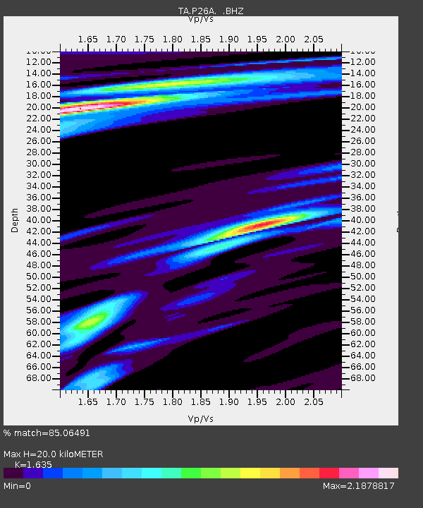
| Estimated Moho Depth: |
20.0 km |
| Estimated Crust Vp/Vs: |
1.63 |
| Assumed Crust Vp: |
6.242 km/s |
| Estimated Crust Vs: |
3.818 km/s |
| Estimated Crust Poisson's Ratio: |
0.20 |
|
| Radial Match: |
85.06491 % |
| Radial Bump: |
280 |
| Transverse Match: |
52.01897 % |
| Transverse Bump: |
400 |
| SOD ConfigId: |
2834 |
| Insert Time: |
2010-03-06 19:41:06.766 +0000 |
| GWidth: |
2.5 |
| Max Bumps: |
400 |
| Tol: |
0.001 |
|

Signal To Noise
| Channel | StoN | STA | LTA |
| TA:P26A: :BHZ:20090108T19:27:47.050002Z | 3.8270524 | 1.1374351E-6 | 2.972092E-7 |
| TA:P26A: :BHN:20090108T19:27:47.050002Z | 0.8933035 | 7.175431E-7 | 8.032467E-7 |
| TA:P26A: :BHE:20090108T19:27:47.050002Z | 1.1294726 | 5.403888E-7 | 4.7844344E-7 |
| Arrivals |
| Ps | 2.2 SECOND |
| PpPs | 7.8 SECOND |
| PsPs/PpSs | 10 SECOND |


