You are here: Home > Network List > GS - US Geological Survey Networks Stations List
> Station OK032 Salt Plains WLR near Rte 11, Oklahoma, USA > Earthquake Result Viewer
OK032 Salt Plains WLR near Rte 11, Oklahoma, USA - Earthquake Result Viewer
| Earthquake location: |
Northern Peru |
| Earthquake latitude/longitude: |
-5.6/-77.0 |
| Earthquake time(UTC): |
2016/09/10 (254) 10:08:20 GMT |
| Earthquake Depth: |
114 km |
| Earthquake Magnitude: |
6.0 MB |
| Earthquake Catalog/Contributor: |
NEIC PDE/NEIC ALERT |
|
| Network: |
GS US Geological Survey Networks |
| Station: |
OK032 Salt Plains WLR near Rte 11, Oklahoma, USA |
| Lat/Lon: |
36.80 N/98.21 W |
| Elevation: |
345 m |
|
| Distance: |
46.6 deg |
| Az: |
336.409 deg |
| Baz: |
150.245 deg |
| Ray Param: |
0.07013127 |
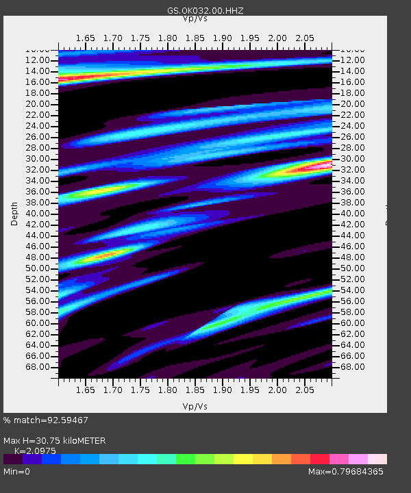
| Estimated Moho Depth: |
30.75 km |
| Estimated Crust Vp/Vs: |
2.10 |
| Assumed Crust Vp: |
6.426 km/s |
| Estimated Crust Vs: |
3.064 km/s |
| Estimated Crust Poisson's Ratio: |
0.35 |
|
| Radial Match: |
92.59467 % |
| Radial Bump: |
400 |
| Transverse Match: |
64.74072 % |
| Transverse Bump: |
400 |
| SOD ConfigId: |
1634031 |
| Insert Time: |
2016-09-24 10:11:52.252 +0000 |
| GWidth: |
2.5 |
| Max Bumps: |
400 |
| Tol: |
0.001 |
|

Signal To Noise
| Channel | StoN | STA | LTA |
| GS:OK032:00:HHZ:20160910T10:16:06.164001Z | 48.01182 | 4.2854667E-6 | 8.925856E-8 |
| GS:OK032:00:HH1:20160910T10:16:06.164001Z | 16.303541 | 2.1085084E-6 | 1.2932826E-7 |
| GS:OK032:00:HH2:20160910T10:16:06.164001Z | 9.6817465 | 1.6285763E-6 | 1.68211E-7 |
| Arrivals |
| Ps | 5.5 SECOND |
| PpPs | 14 SECOND |
| PsPs/PpSs | 20 SECOND |


