You are here: Home > Network List > GS - US Geological Survey Networks Stations List
> Station OK034 N. Norfolk Rd., Cushing, Oklahoma, USA > Earthquake Result Viewer
OK034 N. Norfolk Rd., Cushing, Oklahoma, USA - Earthquake Result Viewer
| Earthquake location: |
Northern Peru |
| Earthquake latitude/longitude: |
-5.6/-77.0 |
| Earthquake time(UTC): |
2016/09/10 (254) 10:08:20 GMT |
| Earthquake Depth: |
114 km |
| Earthquake Magnitude: |
6.0 MB |
| Earthquake Catalog/Contributor: |
NEIC PDE/NEIC ALERT |
|
| Network: |
GS US Geological Survey Networks |
| Station: |
OK034 N. Norfolk Rd., Cushing, Oklahoma, USA |
| Lat/Lon: |
36.01 N/96.71 W |
| Elevation: |
254 m |
|
| Distance: |
45.3 deg |
| Az: |
337.345 deg |
| Baz: |
151.78 deg |
| Ray Param: |
0.07094185 |
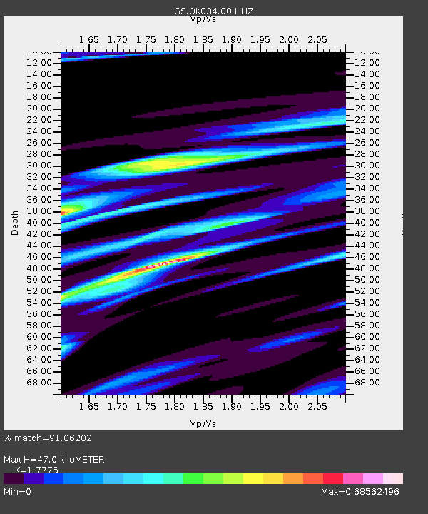
| Estimated Moho Depth: |
47.0 km |
| Estimated Crust Vp/Vs: |
1.78 |
| Assumed Crust Vp: |
6.483 km/s |
| Estimated Crust Vs: |
3.647 km/s |
| Estimated Crust Poisson's Ratio: |
0.27 |
|
| Radial Match: |
91.06202 % |
| Radial Bump: |
342 |
| Transverse Match: |
55.90985 % |
| Transverse Bump: |
400 |
| SOD ConfigId: |
1634031 |
| Insert Time: |
2016-09-24 10:11:55.115 +0000 |
| GWidth: |
2.5 |
| Max Bumps: |
400 |
| Tol: |
0.001 |
|

Signal To Noise
| Channel | StoN | STA | LTA |
| GS:OK034:00:HHZ:20160910T10:15:56.148987Z | 41.50124 | 5.215079E-6 | 1.256608E-7 |
| GS:OK034:00:HH1:20160910T10:15:56.148987Z | 10.319973 | 3.4432483E-6 | 3.3364896E-7 |
| GS:OK034:00:HH2:20160910T10:15:56.148987Z | 3.8516335 | 1.7277815E-6 | 4.485841E-7 |
| Arrivals |
| Ps | 6.0 SECOND |
| PpPs | 19 SECOND |
| PsPs/PpSs | 25 SECOND |


