You are here: Home > Network List > TA - USArray Transportable Network (new EarthScope stations) Stations List
> Station P17K Kvichak River, AK, USA > Earthquake Result Viewer
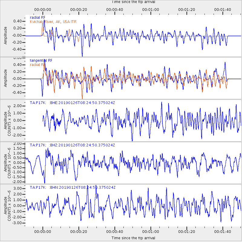
P17K Kvichak River, AK, USA - Earthquake Result Viewer
*The percent match for this event was below the threshold and hence no stack was calculated.
| Earthquake location: |
Aru Islands Region, Indonesia |
| Earthquake latitude/longitude: |
-5.5/133.8 |
| Earthquake time(UTC): |
2019/01/26 (026) 08:12:48 GMT |
| Earthquake Depth: |
10 km |
| Earthquake Magnitude: |
5.8 Mww |
| Earthquake Catalog/Contributor: |
NEIC PDE/us |
|
| Network: |
TA USArray Transportable Network (new EarthScope stations) |
| Station: |
P17K Kvichak River, AK, USA |
| Lat/Lon: |
59.20 N/156.44 W |
| Elevation: |
91 m |
|
| Distance: |
84.5 deg |
| Az: |
29.026 deg |
| Baz: |
249.803 deg |
| Ray Param: |
$rayparam |
*The percent match for this event was below the threshold and hence was not used in the summary stack. |
|
| Radial Match: |
51.496094 % |
| Radial Bump: |
400 |
| Transverse Match: |
51.73624 % |
| Transverse Bump: |
400 |
| SOD ConfigId: |
13570011 |
| Insert Time: |
2019-05-02 09:38:39.452 +0000 |
| GWidth: |
2.5 |
| Max Bumps: |
400 |
| Tol: |
0.001 |
|
Signal To Noise
| Channel | StoN | STA | LTA |
| TA:P17K: :BHZ:20190126T08:24:50.375024Z | 2.1229973 | 1.0685554E-6 | 5.0332403E-7 |
| TA:P17K: :BHN:20190126T08:24:50.375024Z | 1.1504881 | 9.553543E-7 | 8.303904E-7 |
| TA:P17K: :BHE:20190126T08:24:50.375024Z | 1.2935076 | 8.353048E-7 | 6.4576716E-7 |
| Arrivals |
| Ps | |
| PpPs | |
| PsPs/PpSs | |


