You are here: Home > Network List > TA - USArray Transportable Network (new EarthScope stations) Stations List
> Station P26A Davis Ranch, Arriba, CO, USA > Earthquake Result Viewer
P26A Davis Ranch, Arriba, CO, USA - Earthquake Result Viewer
| Earthquake location: |
North Of Svalbard |
| Earthquake latitude/longitude: |
80.3/-1.9 |
| Earthquake time(UTC): |
2009/03/06 (065) 10:50:29 GMT |
| Earthquake Depth: |
9.0 km |
| Earthquake Magnitude: |
6.6 MB, 6.5 MS, 6.5 MW, 6.4 MW |
| Earthquake Catalog/Contributor: |
WHDF/NEIC |
|
| Network: |
TA USArray Transportable Network (new EarthScope stations) |
| Station: |
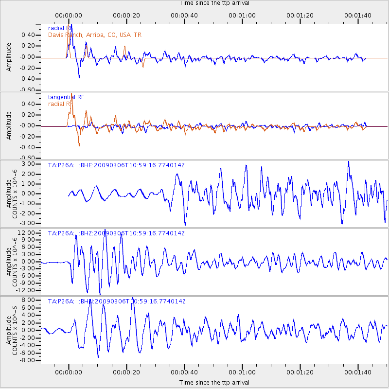
P26A Davis Ranch, Arriba, CO, USA |
| Lat/Lon: |
39.56 N/103.35 W |
| Elevation: |
1566 m |
|
| Distance: |
53.2 deg |
| Az: |
288.884 deg |
| Baz: |
11.95 deg |
| Ray Param: |
0.066267766 |
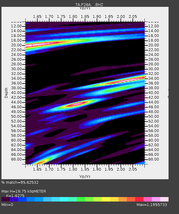
| Estimated Moho Depth: |
19.75 km |
| Estimated Crust Vp/Vs: |
1.63 |
| Assumed Crust Vp: |
6.242 km/s |
| Estimated Crust Vs: |
3.835 km/s |
| Estimated Crust Poisson's Ratio: |
0.20 |
|
| Radial Match: |
95.62532 % |
| Radial Bump: |
359 |
| Transverse Match: |
78.30553 % |
| Transverse Bump: |
400 |
| SOD ConfigId: |
2658 |
| Insert Time: |
2010-03-06 19:41:34.174 +0000 |
| GWidth: |
2.5 |
| Max Bumps: |
400 |
| Tol: |
0.001 |
|
Signal To Noise
| Channel | StoN | STA | LTA |
| TA:P26A: :BHZ:20090306T10:59:16.774014Z | 24.761683 | 5.243717E-6 | 2.117674E-7 |
| TA:P26A: :BHN:20090306T10:59:16.774014Z | 4.228285 | 2.5236227E-6 | 5.968431E-7 |
| TA:P26A: :BHE:20090306T10:59:16.774014Z | 1.122298 | 4.0704705E-7 | 3.626907E-7 |
| Arrivals |
| Ps | 2.1 SECOND |
| PpPs | 7.9 SECOND |
| PsPs/PpSs | 10.0 SECOND |


