You are here: Home > Network List > TA - USArray Transportable Network (new EarthScope stations) Stations List
> Station P26A Davis Ranch, Arriba, CO, USA > Earthquake Result Viewer
P26A Davis Ranch, Arriba, CO, USA - Earthquake Result Viewer
| Earthquake location: |
Kuril Islands |
| Earthquake latitude/longitude: |
46.0/151.5 |
| Earthquake time(UTC): |
2009/04/07 (097) 04:23:33 GMT |
| Earthquake Depth: |
31 km |
| Earthquake Magnitude: |
6.5 MB, 6.8 MS, 6.9 MW, 6.9 MW |
| Earthquake Catalog/Contributor: |
WHDF/NEIC |
|
| Network: |
TA USArray Transportable Network (new EarthScope stations) |
| Station: |
P26A Davis Ranch, Arriba, CO, USA |
| Lat/Lon: |
39.56 N/103.35 W |
| Elevation: |
1566 m |
|
| Distance: |
71.6 deg |
| Az: |
51.845 deg |
| Baz: |
314.892 deg |
| Ray Param: |
0.054144766 |
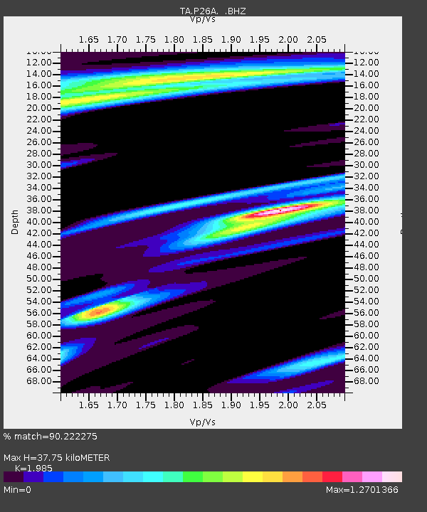
| Estimated Moho Depth: |
37.75 km |
| Estimated Crust Vp/Vs: |
1.99 |
| Assumed Crust Vp: |
6.242 km/s |
| Estimated Crust Vs: |
3.145 km/s |
| Estimated Crust Poisson's Ratio: |
0.33 |
|
| Radial Match: |
90.222275 % |
| Radial Bump: |
305 |
| Transverse Match: |
66.153 % |
| Transverse Bump: |
350 |
| SOD ConfigId: |
2658 |
| Insert Time: |
2010-03-06 19:41:42.062 +0000 |
| GWidth: |
2.5 |
| Max Bumps: |
400 |
| Tol: |
0.001 |
|
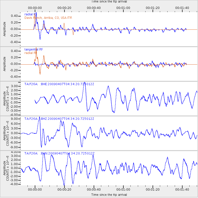
Signal To Noise
| Channel | StoN | STA | LTA |
| TA:P26A: :BHZ:20090407T04:34:20.725012Z | 25.7874 | 5.428411E-6 | 2.1050634E-7 |
| TA:P26A: :BHN:20090407T04:34:20.725012Z | 3.8007426 | 1.5994436E-6 | 4.2082397E-7 |
| TA:P26A: :BHE:20090407T04:34:20.725012Z | 3.5246155 | 2.0787113E-6 | 5.897696E-7 |
| Arrivals |
| Ps | 6.1 SECOND |
| PpPs | 18 SECOND |
| PsPs/PpSs | 24 SECOND |


