You are here: Home > Network List > TA - USArray Transportable Network (new EarthScope stations) Stations List
> Station P26A Davis Ranch, Arriba, CO, USA > Earthquake Result Viewer
P26A Davis Ranch, Arriba, CO, USA - Earthquake Result Viewer
| Earthquake location: |
Off Coast Of Ecuador |
| Earthquake latitude/longitude: |
1.4/-85.2 |
| Earthquake time(UTC): |
2009/05/10 (130) 01:16:06 GMT |
| Earthquake Depth: |
6.0 km |
| Earthquake Magnitude: |
5.5 MB, 5.7 MS, 6.1 MW, 6.1 MW |
| Earthquake Catalog/Contributor: |
WHDF/NEIC |
|
| Network: |
TA USArray Transportable Network (new EarthScope stations) |
| Station: |
P26A Davis Ranch, Arriba, CO, USA |
| Lat/Lon: |
39.56 N/103.35 W |
| Elevation: |
1566 m |
|
| Distance: |
41.4 deg |
| Az: |
338.633 deg |
| Baz: |
151.89 deg |
| Ray Param: |
0.07379749 |
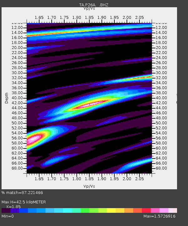
| Estimated Moho Depth: |
42.5 km |
| Estimated Crust Vp/Vs: |
1.85 |
| Assumed Crust Vp: |
6.242 km/s |
| Estimated Crust Vs: |
3.374 km/s |
| Estimated Crust Poisson's Ratio: |
0.29 |
|
| Radial Match: |
87.221466 % |
| Radial Bump: |
339 |
| Transverse Match: |
42.749733 % |
| Transverse Bump: |
302 |
| SOD ConfigId: |
2760 |
| Insert Time: |
2010-03-06 19:41:46.114 +0000 |
| GWidth: |
2.5 |
| Max Bumps: |
400 |
| Tol: |
0.001 |
|
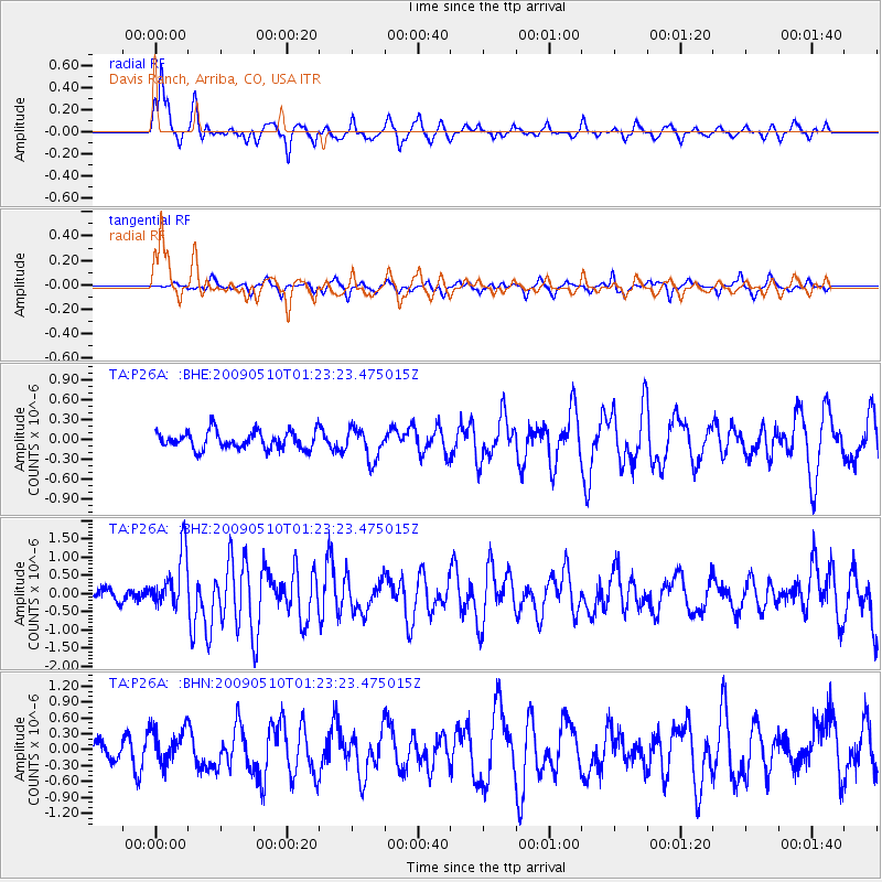
Signal To Noise
| Channel | StoN | STA | LTA |
| TA:P26A: :BHZ:20090510T01:23:23.475015Z | 4.8662806 | 7.5863676E-7 | 1.5589663E-7 |
| TA:P26A: :BHN:20090510T01:23:23.475015Z | 2.0575879 | 3.433703E-7 | 1.6688E-7 |
| TA:P26A: :BHE:20090510T01:23:23.475015Z | 1.8012145 | 2.3735086E-7 | 1.3177268E-7 |
| Arrivals |
| Ps | 6.2 SECOND |
| PpPs | 18 SECOND |
| PsPs/PpSs | 24 SECOND |


