You are here: Home > Network List > TA - USArray Transportable Network (new EarthScope stations) Stations List
> Station P26A Davis Ranch, Arriba, CO, USA > Earthquake Result Viewer
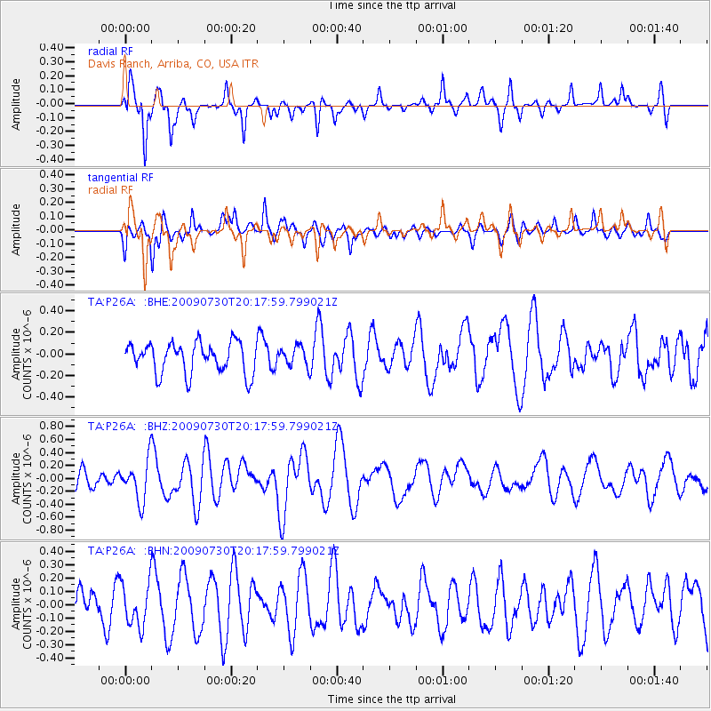
P26A Davis Ranch, Arriba, CO, USA - Earthquake Result Viewer
*The percent match for this event was below the threshold and hence no stack was calculated.
| Earthquake location: |
Tonga Islands |
| Earthquake latitude/longitude: |
-20.8/-174.3 |
| Earthquake time(UTC): |
2009/07/30 (211) 20:05:34 GMT |
| Earthquake Depth: |
10 km |
| Earthquake Magnitude: |
5.9 MB, 5.7 MS, 5.8 MW, 5.7 MW |
| Earthquake Catalog/Contributor: |
WHDF/NEIC |
|
| Network: |
TA USArray Transportable Network (new EarthScope stations) |
| Station: |
P26A Davis Ranch, Arriba, CO, USA |
| Lat/Lon: |
39.56 N/103.35 W |
| Elevation: |
1566 m |
|
| Distance: |
89.3 deg |
| Az: |
46.935 deg |
| Baz: |
242.12 deg |
| Ray Param: |
$rayparam |
*The percent match for this event was below the threshold and hence was not used in the summary stack. |
|
| Radial Match: |
76.999245 % |
| Radial Bump: |
299 |
| Transverse Match: |
66.7466 % |
| Transverse Bump: |
400 |
| SOD ConfigId: |
2622 |
| Insert Time: |
2010-03-06 19:41:55.965 +0000 |
| GWidth: |
2.5 |
| Max Bumps: |
400 |
| Tol: |
0.001 |
|
Signal To Noise
| Channel | StoN | STA | LTA |
| TA:P26A: :BHZ:20090730T20:17:59.799021Z | 2.9465454 | 3.1731506E-7 | 1.07690546E-7 |
| TA:P26A: :BHN:20090730T20:17:59.799021Z | 1.4987513 | 1.6197066E-7 | 1.0807041E-7 |
| TA:P26A: :BHE:20090730T20:17:59.799021Z | 0.6363271 | 9.1001056E-8 | 1.4300987E-7 |
| Arrivals |
| Ps | |
| PpPs | |
| PsPs/PpSs | |


