You are here: Home > Network List > TA - USArray Transportable Network (new EarthScope stations) Stations List
> Station P26A Davis Ranch, Arriba, CO, USA > Earthquake Result Viewer
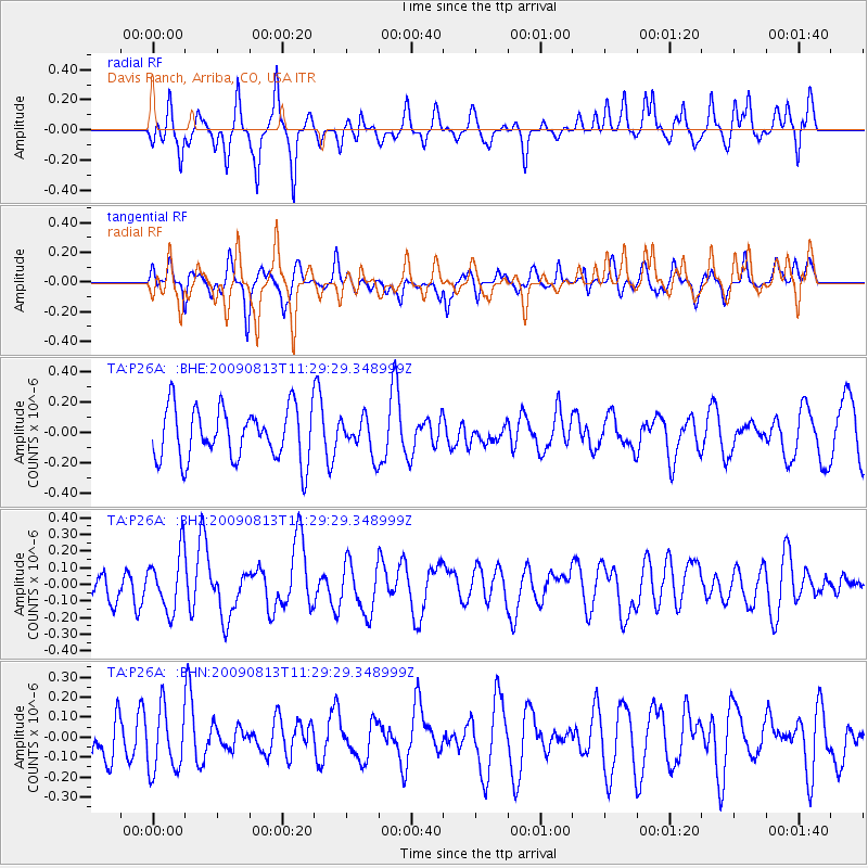
P26A Davis Ranch, Arriba, CO, USA - Earthquake Result Viewer
*The percent match for this event was below the threshold and hence no stack was calculated.
| Earthquake location: |
Tonga Islands |
| Earthquake latitude/longitude: |
-21.7/-174.6 |
| Earthquake time(UTC): |
2009/08/13 (225) 11:17:01 GMT |
| Earthquake Depth: |
10 km |
| Earthquake Magnitude: |
5.6 MW, 5.3 MB |
| Earthquake Catalog/Contributor: |
WHDF/NEIC |
|
| Network: |
TA USArray Transportable Network (new EarthScope stations) |
| Station: |
P26A Davis Ranch, Arriba, CO, USA |
| Lat/Lon: |
39.56 N/103.35 W |
| Elevation: |
1566 m |
|
| Distance: |
90.1 deg |
| Az: |
47.045 deg |
| Baz: |
241.726 deg |
| Ray Param: |
$rayparam |
*The percent match for this event was below the threshold and hence was not used in the summary stack. |
|
| Radial Match: |
61.203526 % |
| Radial Bump: |
400 |
| Transverse Match: |
37.032265 % |
| Transverse Bump: |
371 |
| SOD ConfigId: |
2622 |
| Insert Time: |
2010-03-06 19:42:02.153 +0000 |
| GWidth: |
2.5 |
| Max Bumps: |
400 |
| Tol: |
0.001 |
|
Signal To Noise
| Channel | StoN | STA | LTA |
| TA:P26A: :BHZ:20090813T11:29:29.348999Z | 2.4609149 | 1.7372867E-7 | 7.0595156E-8 |
| TA:P26A: :BHN:20090813T11:29:29.348999Z | 1.3740329 | 1.5915472E-7 | 1.1583037E-7 |
| TA:P26A: :BHE:20090813T11:29:29.348999Z | 0.68731207 | 1.1884236E-7 | 1.7290887E-7 |
| Arrivals |
| Ps | |
| PpPs | |
| PsPs/PpSs | |


