You are here: Home > Network List > TA - USArray Transportable Network (new EarthScope stations) Stations List
> Station P26A Davis Ranch, Arriba, CO, USA > Earthquake Result Viewer
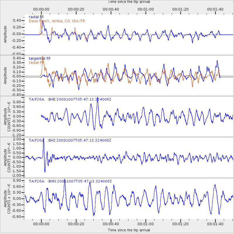
P26A Davis Ranch, Arriba, CO, USA - Earthquake Result Viewer
*The percent match for this event was below the threshold and hence no stack was calculated.
| Earthquake location: |
Rat Islands, Aleutian Islands |
| Earthquake latitude/longitude: |
52.2/178.1 |
| Earthquake time(UTC): |
2009/10/07 (280) 05:38:37 GMT |
| Earthquake Depth: |
138 km |
| Earthquake Magnitude: |
5.6 MB, 5.6 MW, 5.6 MW |
| Earthquake Catalog/Contributor: |
WHDF/NEIC |
|
| Network: |
TA USArray Transportable Network (new EarthScope stations) |
| Station: |
P26A Davis Ranch, Arriba, CO, USA |
| Lat/Lon: |
39.56 N/103.35 W |
| Elevation: |
1566 m |
|
| Distance: |
53.6 deg |
| Az: |
70.359 deg |
| Baz: |
311.361 deg |
| Ray Param: |
$rayparam |
*The percent match for this event was below the threshold and hence was not used in the summary stack. |
|
| Radial Match: |
46.151264 % |
| Radial Bump: |
325 |
| Transverse Match: |
41.066025 % |
| Transverse Bump: |
294 |
| SOD ConfigId: |
2622 |
| Insert Time: |
2010-03-06 19:42:11.596 +0000 |
| GWidth: |
2.5 |
| Max Bumps: |
400 |
| Tol: |
0.001 |
|
Signal To Noise
| Channel | StoN | STA | LTA |
| TA:P26A: :BHZ:20091007T05:47:13.324006Z | 6.2081394 | 7.8334045E-7 | 1.2617959E-7 |
| TA:P26A: :BHN:20091007T05:47:13.324006Z | 2.0548167 | 3.5743244E-7 | 1.7394859E-7 |
| TA:P26A: :BHE:20091007T05:47:13.324006Z | 2.8411982 | 6.1011843E-7 | 2.1473984E-7 |
| Arrivals |
| Ps | |
| PpPs | |
| PsPs/PpSs | |


