You are here: Home > Network List > TA - USArray Transportable Network (new EarthScope stations) Stations List
> Station I30M Mount Dempster, Yukon, CAN > Earthquake Result Viewer
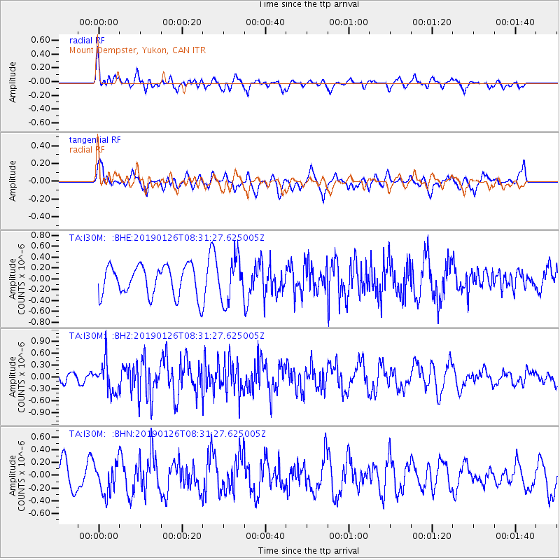
I30M Mount Dempster, Yukon, CAN - Earthquake Result Viewer
*The percent match for this event was below the threshold and hence no stack was calculated.
| Earthquake location: |
Near East Coast Of Honshu, Japan |
| Earthquake latitude/longitude: |
40.3/142.2 |
| Earthquake time(UTC): |
2019/01/26 (026) 08:23:02 GMT |
| Earthquake Depth: |
37 km |
| Earthquake Magnitude: |
5.5 Mww |
| Earthquake Catalog/Contributor: |
NEIC PDE/us |
|
| Network: |
TA USArray Transportable Network (new EarthScope stations) |
| Station: |
I30M Mount Dempster, Yukon, CAN |
| Lat/Lon: |
65.22 N/136.38 W |
| Elevation: |
1399 m |
|
| Distance: |
50.7 deg |
| Az: |
32.559 deg |
| Baz: |
282.563 deg |
| Ray Param: |
$rayparam |
*The percent match for this event was below the threshold and hence was not used in the summary stack. |
|
| Radial Match: |
44.637417 % |
| Radial Bump: |
400 |
| Transverse Match: |
58.531864 % |
| Transverse Bump: |
400 |
| SOD ConfigId: |
13570011 |
| Insert Time: |
2019-05-02 09:47:09.254 +0000 |
| GWidth: |
2.5 |
| Max Bumps: |
400 |
| Tol: |
0.001 |
|
Signal To Noise
| Channel | StoN | STA | LTA |
| TA:I30M: :BHZ:20190126T08:31:27.625005Z | 2.52939 | 3.94856E-7 | 1.5610719E-7 |
| TA:I30M: :BHN:20190126T08:31:27.625005Z | 1.5299017 | 2.3648026E-7 | 1.5457219E-7 |
| TA:I30M: :BHE:20190126T08:31:27.625005Z | 1.4530058 | 4.0597936E-7 | 2.7940658E-7 |
| Arrivals |
| Ps | |
| PpPs | |
| PsPs/PpSs | |


