You are here: Home > Network List > TA - USArray Transportable Network (new EarthScope stations) Stations List
> Station R32K Eaglecrest, AK, USA > Earthquake Result Viewer
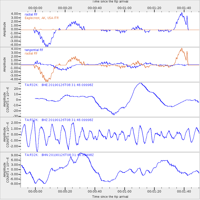
R32K Eaglecrest, AK, USA - Earthquake Result Viewer
*The percent match for this event was below the threshold and hence no stack was calculated.
| Earthquake location: |
Near East Coast Of Honshu, Japan |
| Earthquake latitude/longitude: |
40.3/142.2 |
| Earthquake time(UTC): |
2019/01/26 (026) 08:23:02 GMT |
| Earthquake Depth: |
37 km |
| Earthquake Magnitude: |
5.5 Mww |
| Earthquake Catalog/Contributor: |
NEIC PDE/us |
|
| Network: |
TA USArray Transportable Network (new EarthScope stations) |
| Station: |
R32K Eaglecrest, AK, USA |
| Lat/Lon: |
58.27 N/134.52 W |
| Elevation: |
386 m |
|
| Distance: |
53.5 deg |
| Az: |
40.749 deg |
| Baz: |
289.236 deg |
| Ray Param: |
$rayparam |
*The percent match for this event was below the threshold and hence was not used in the summary stack. |
|
| Radial Match: |
11.835055 % |
| Radial Bump: |
400 |
| Transverse Match: |
13.463464 % |
| Transverse Bump: |
400 |
| SOD ConfigId: |
13570011 |
| Insert Time: |
2019-05-02 09:47:25.932 +0000 |
| GWidth: |
2.5 |
| Max Bumps: |
400 |
| Tol: |
0.001 |
|
Signal To Noise
| Channel | StoN | STA | LTA |
| TA:R32K: :BHZ:20190126T08:31:48.09998Z | 1.7669961 | 1.6596665E-6 | 9.392587E-7 |
| TA:R32K: :BHN:20190126T08:31:48.09998Z | 6.3230453 | 8.795573E-6 | 1.3910343E-6 |
| TA:R32K: :BHE:20190126T08:31:48.09998Z | 1.0695286 | 3.9033303E-6 | 3.6495803E-6 |
| Arrivals |
| Ps | |
| PpPs | |
| PsPs/PpSs | |


