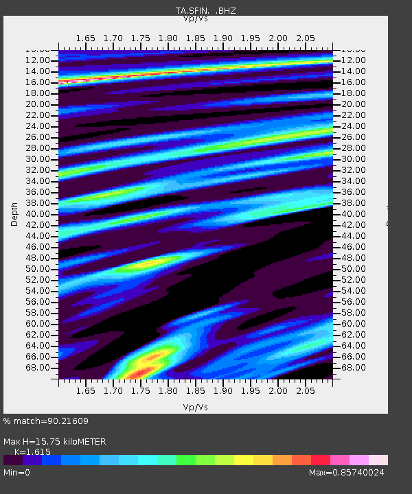
SFIN Lafayette, IN, USA - Earthquake Result Viewer

Earthquake location: Rat Islands, Aleutian Islands
Earthquake latitude/longitude: 50.4/177.0
Earthquake time(UTC): 2009/07/06 (187) 14:53:12 GMT
Earthquake Depth: 22 km
Earthquake Magnitude: 6.0 MB, 5.8 MS, 6.1 MW, 6.0 MW
Earthquake Catalog/Contributor: WHDF/NEIC
Network: TA USArray Transportable Network (new EarthScope stations)
Station: SFIN Lafayette, IN, USA
Lat/Lon: 40.38 N/87.10 W
Elevation: 165 m
Distance: 63.5 deg
Az: 58.09 deg
Baz: 314.715 deg
Ray Param: 0.059494033
Estimated Moho Depth: 15.75 km
Estimated Crust Vp/Vs: 1.62
Assumed Crust Vp: 6.498 km/s
Estimated Crust Vs: 4.023 km/s
Estimated Crust Poisson's Ratio: 0.19
Radial Match: 90.21609 %
Radial Bump: 400
Transverse Match: 83.78188 %
Transverse Bump: 400
SOD ConfigId: 2622
Insert Time: 2010-03-06 19:42:58.654 +0000
GWidth: 2.5
Max Bumps: 400
Tol: 0.001

Signal To Noise

ChannelStoNSTALTA
TA:SFIN: :BHZ:20090706T15:03:09.724009Z13.905282.5663674E-61.8456065E-7
TA:SFIN: :BHN:20090706T15:03:09.724009Z6.68920667.8865236E-71.1789923E-7
TA:SFIN: :BHE:20090706T15:03:09.724009Z5.11269336.914934E-71.3525033E-7
Arrivals
Ps1.6 SECOND
PpPs6.0 SECOND
PsPs/PpSs7.6 SECOND