You are here: Home > Network List > TA - USArray Transportable Network (new EarthScope stations) Stations List
> Station SFIN Lafayette, IN, USA > Earthquake Result Viewer
SFIN Lafayette, IN, USA - Earthquake Result Viewer
| Earthquake location: |
Samoa Islands Region |
| Earthquake latitude/longitude: |
-15.9/-171.7 |
| Earthquake time(UTC): |
2009/09/29 (272) 18:19:35 GMT |
| Earthquake Depth: |
10 km |
| Earthquake Magnitude: |
5.6 MB |
| Earthquake Catalog/Contributor: |
WHDF/NEIC |
|
| Network: |
TA USArray Transportable Network (new EarthScope stations) |
| Station: |
SFIN Lafayette, IN, USA |
| Lat/Lon: |
40.38 N/87.10 W |
| Elevation: |
165 m |
|
| Distance: |
96.1 deg |
| Az: |
49.892 deg |
| Baz: |
254.404 deg |
| Ray Param: |
0.04060264 |
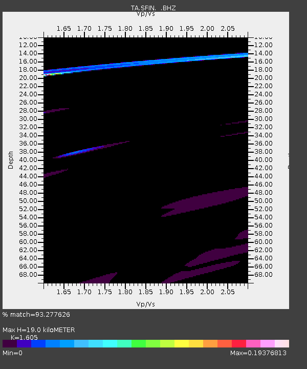
| Estimated Moho Depth: |
19.0 km |
| Estimated Crust Vp/Vs: |
1.61 |
| Assumed Crust Vp: |
6.498 km/s |
| Estimated Crust Vs: |
4.048 km/s |
| Estimated Crust Poisson's Ratio: |
0.18 |
|
| Radial Match: |
93.277626 % |
| Radial Bump: |
324 |
| Transverse Match: |
25.258121 % |
| Transverse Bump: |
235 |
| SOD ConfigId: |
2622 |
| Insert Time: |
2010-03-06 19:43:07.649 +0000 |
| GWidth: |
2.5 |
| Max Bumps: |
400 |
| Tol: |
0.001 |
|
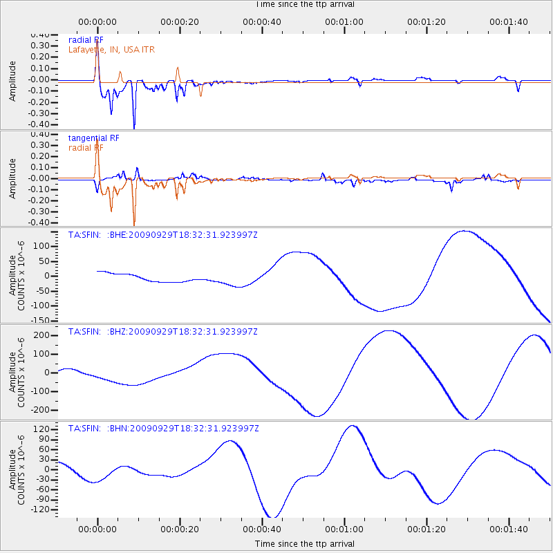
Signal To Noise
| Channel | StoN | STA | LTA |
| TA:SFIN: :BHZ:20090929T18:32:31.923997Z | 3.5274267 | 4.00328E-5 | 1.134901E-5 |
| TA:SFIN: :BHN:20090929T18:32:31.923997Z | 0.9781255 | 2.477712E-5 | 2.5331228E-5 |
| TA:SFIN: :BHE:20090929T18:32:31.923997Z | 1.7678151 | 2.3723976E-5 | 1.3419942E-5 |
| Arrivals |
| Ps | 1.8 SECOND |
| PpPs | 7.5 SECOND |
| PsPs/PpSs | 9.3 SECOND |


