You are here: Home > Network List > TA - USArray Transportable Network (new EarthScope stations) Stations List
> Station SFIN Lafayette, IN, USA > Earthquake Result Viewer
SFIN Lafayette, IN, USA - Earthquake Result Viewer

| Earthquake location: |
Azores Islands Region |
| Earthquake latitude/longitude: |
36.2/-33.9 |
| Earthquake time(UTC): |
2009/11/04 (308) 18:41:44 GMT |
| Earthquake Depth: |
10 km |
| Earthquake Magnitude: |
5.7 MB, 5.6 MS, 5.9 MW, 5.8 MW |
| Earthquake Catalog/Contributor: |
WHDF/NEIC |
|
| Network: |
TA USArray Transportable Network (new EarthScope stations) |
| Station: |
SFIN Lafayette, IN, USA |
| Lat/Lon: |
40.38 N/87.10 W |
| Elevation: |
165 m |
|
| Distance: |
41.5 deg |
| Az: |
292.514 deg |
| Baz: |
78.149 deg |
| Ray Param: |
0.07376582 |
| Estimated Moho Depth: |
63.75 km |
| Estimated Crust Vp/Vs: |
1.77 |
| Assumed Crust Vp: |
6.498 km/s |
| Estimated Crust Vs: |
3.671 km/s |
| Estimated Crust Poisson's Ratio: |
0.27 |
|
| Radial Match: |
89.98664 % |
| Radial Bump: |
293 |
| Transverse Match: |
72.08724 % |
| Transverse Bump: |
349 |
| SOD ConfigId: |
2622 |
| Insert Time: |
2010-03-06 19:43:11.476 +0000 |
| GWidth: |
2.5 |
| Max Bumps: |
400 |
| Tol: |
0.001 |
|
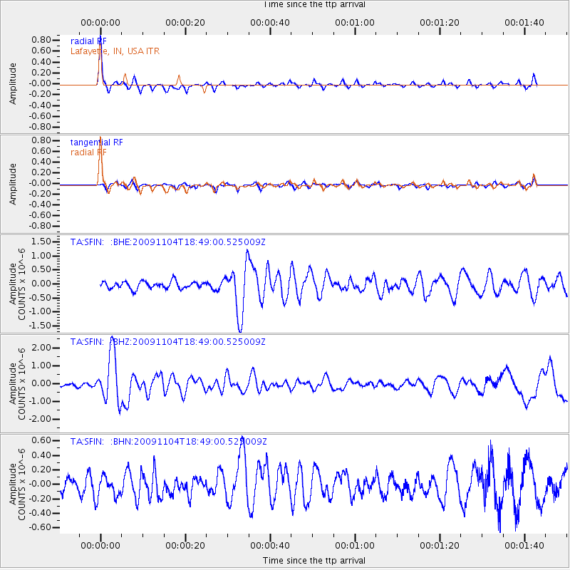
Signal To Noise
| Channel | StoN | STA | LTA |
| TA:SFIN: :BHZ:20091104T18:49:00.525009Z | 13.744733 | 1.378172E-6 | 1.002691E-7 |
| TA:SFIN: :BHN:20091104T18:49:00.525009Z | 1.1567066 | 1.4772509E-7 | 1.277118E-7 |
| TA:SFIN: :BHE:20091104T18:49:00.525009Z | 6.9621162 | 8.8171606E-7 | 1.2664484E-7 |
| Arrivals |
| Ps | 8.1 SECOND |
| PpPs | 25 SECOND |
| PsPs/PpSs | 33 SECOND |


