You are here: Home > Network List > TA - USArray Transportable Network (new EarthScope stations) Stations List
> Station 121A Cookes Peak, Deming, NM, USA > Earthquake Result Viewer
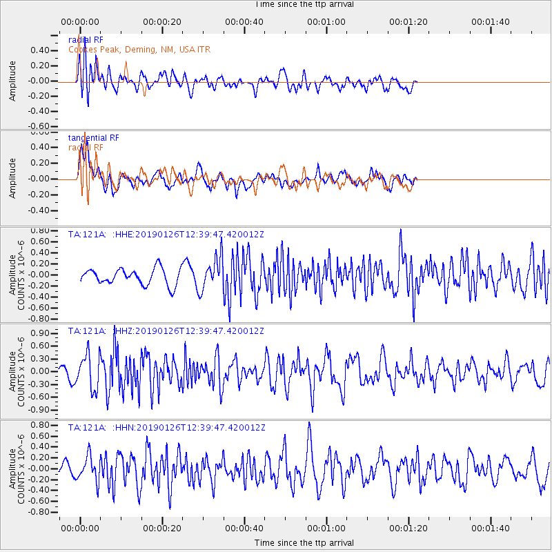
121A Cookes Peak, Deming, NM, USA - Earthquake Result Viewer
*The percent match for this event was below the threshold and hence no stack was calculated.
| Earthquake location: |
Colombia |
| Earthquake latitude/longitude: |
3.0/-75.8 |
| Earthquake time(UTC): |
2019/01/26 (026) 12:32:27 GMT |
| Earthquake Depth: |
10 km |
| Earthquake Magnitude: |
5.6 Mww |
| Earthquake Catalog/Contributor: |
NEIC PDE/us |
|
| Network: |
TA USArray Transportable Network (new EarthScope stations) |
| Station: |
121A Cookes Peak, Deming, NM, USA |
| Lat/Lon: |
32.53 N/107.79 W |
| Elevation: |
1652 m |
|
| Distance: |
42.0 deg |
| Az: |
318.001 deg |
| Baz: |
127.715 deg |
| Ray Param: |
$rayparam |
*The percent match for this event was below the threshold and hence was not used in the summary stack. |
|
| Radial Match: |
74.08824 % |
| Radial Bump: |
400 |
| Transverse Match: |
67.54518 % |
| Transverse Bump: |
400 |
| SOD ConfigId: |
13570011 |
| Insert Time: |
2019-05-02 09:56:25.798 +0000 |
| GWidth: |
2.5 |
| Max Bumps: |
400 |
| Tol: |
0.001 |
|
Signal To Noise
| Channel | StoN | STA | LTA |
| TA:121A: :HHZ:20190126T12:39:47.420012Z | 3.1386664 | 4.160714E-7 | 1.3256312E-7 |
| TA:121A: :HHN:20190126T12:39:47.420012Z | 1.3328422 | 2.310302E-7 | 1.7333649E-7 |
| TA:121A: :HHE:20190126T12:39:47.420012Z | 2.0041397 | 2.9645682E-7 | 1.4792224E-7 |
| Arrivals |
| Ps | |
| PpPs | |
| PsPs/PpSs | |


